Table Mountain
📍 Cape Town, Western Cape, South Africa
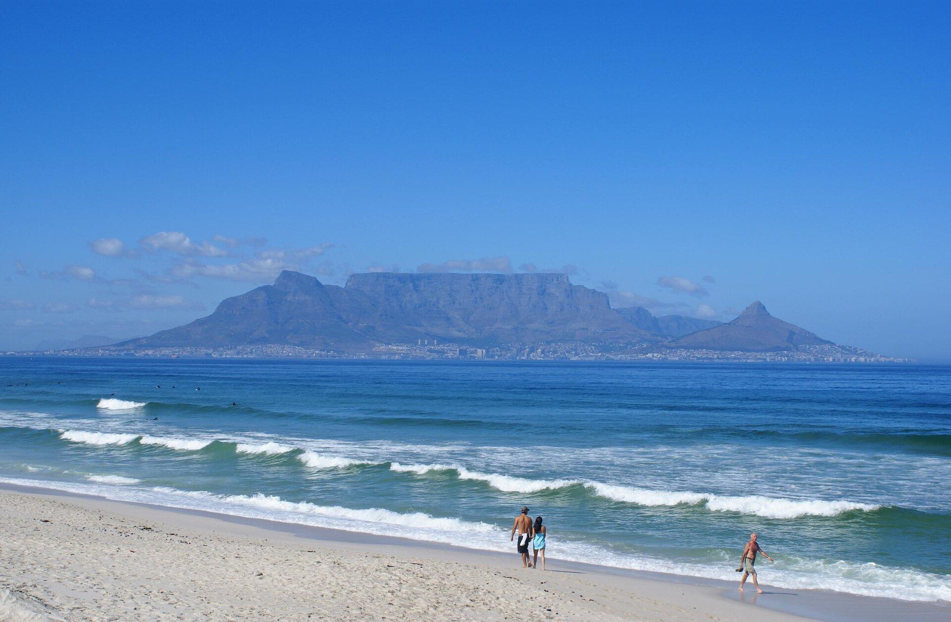
The flat-topped sandstone massif that presides over Cape Town — a sheer-sided landmark often draped in a 'tablecloth' of cloud, and the heart of a plant kingdom so rich it is unique on Earth.
What makes it marvelous
Table Mountain's remarkably level, three-kilometre-long summit is ancient, hard sandstone laid down over 500 million years ago and left standing as softer rock eroded away. Rising some 1,086 metres straight above the sea, it generates its own weather — the famous 'tablecloth' cloud that pours over the rim on southeasterly winds. Most astonishing is its flora: the mountain is the centrepiece of the Cape Floristic Region, the smallest and one of the richest of the world's six floral kingdoms, with thousands of fynbos plant species, many found nowhere else.
Why visit
A revolving cableway (or a strenuous hike) lifts you to a summit with sweeping views over Cape Town, the ocean, and Cape Point, amid fynbos and dassies (rock hyraxes). It's a rare wonder where a great city, a dramatic landform, and a globally unique flora meet.
What to know before you go
🗓️ Best time
The drier, calmer months of roughly February–May and September–November for clear summits; strong wind or the 'tablecloth' cloud can close the cableway.
🧭 Getting there & access
In the heart of Cape Town, reached by the Table Mountain Aerial Cableway or by hiking routes like Platteklip Gorge. Part of Table Mountain National Park.
Good to know
- Go up early — wind and cloud often close the cableway later in the day.
- Check conditions before you set out; the mountain's weather turns fast.
- Stay on paths to protect the fragile, irreplaceable fynbos.
Plan your visit
Moderate🧭 Getting there
From Cape Town, South Africa
- Fly → Cape Town (CPT)
- Drive or ride city centre → the Lower Cableway Station — roughly 15–25 minutes
- Take the rotating cable car up, or hike Platteklip Gorge — about 2h–3h on foot
- Total travel
- Well under an hour from central Cape Town
- Time at site
- Two to four hours on top
- Access
- The rotating cableway is the easy way up and down, but it stops running in high wind and for maintenance, and closes with little notice — check the cableway's live operating status before you set out, and again before you rely on it to come down. On foot, Platteklip Gorge is the direct route; the mountain's weather turns fast and the "tablecloth" cloud can drop visibility to nothing, which is how walkers get lost or benighted. As on any quiet urban trail, walk in a group and keep valuables out of sight.
🎒 What to bring & consider
- A check of the cableway's live status, because a wind closure can leave you facing a long descent on foot you had not planned for
- Warm and windproof layers even on a hot day, since the summit weather is a different climate from the beach below and changes within the hour
- Proper shoes and enough water for Platteklip Gorge, a relentless stone staircase with no shade and no water on it
- A charged phone and a companion, both for the weather and for the ordinary caution of a quiet trail near a big city
- Timing away from the low cloud — if the tablecloth is down, the view is gone and the descent is genuinely hazardous
👁️ What to expect
- Crowds
- Busy at the cable station and the summit railings midday, especially in summer. The trails thin out fast.
- Conditions
- Clear and windless one moment, wrapped in cloud and strong wind the next. Steep on foot.
- Facilities
- A café, shop and toilets at the summit station. Nothing on the hiking routes.
- The view
- The city and Table Bay laid out from the summit edge, with Lion's Head in the frame, in the clear window before the cloud builds. Late afternoon light is best, but leave time and a plan to get down.
Times and requirements are approximate and change with season, weather, and local rules — confirm permits, fares, and schedules with operators before you travel.
Natural riches of the area
- 500-million-year-old sandstone landform
- The Cape Floristic Region — a unique floral kingdom of thousands of fynbos species
- Endemic plants and animals found only here
- Freshwater springs and a globally important biodiversity hotspot
Local food
- Cape Malay curry & bobotie
- Fragrant, mildly sweet Cape cuisine shaped by Malay heritage.
- Snoek & fresh seafood
- Fish from the cold Atlantic and Indian oceans meeting at the Cape.
- Cape wines
- The renowned vineyards of the surrounding Western Cape.
Table Mountain is Cape Town’s presiding presence — a mountain with a summit so level it looks planed flat, three kilometres long and rising over a thousand metres straight from the sea. The tabletop is ancient sandstone, more than 500 million years old, left standing as the softer rock around it wore away. On southeasterly winds it makes its own weather, the famous ‘tablecloth’ of cloud spilling over the rim.
But its greatest wonder is underfoot. The mountain is the heart of the Cape Floristic Region, the smallest of the world’s six floral kingdoms and one of the richest, packed with thousands of species of fynbos shrubs and flowers — an astonishing number of them found nowhere else on the planet. A cableway (or a hard hike) carries you to a summit of endless views and unique plants, where a great city, a dramatic landform, and a one-of-a-kind flora all meet.
Table Mountain: common questions
How do you get to Table Mountain?
From Cape Town, South Africa: Fly → Cape Town (CPT); Drive or ride city centre → the Lower Cableway Station — roughly 15–25 minutes; Take the rotating cable car up, or hike Platteklip Gorge — about 2h–3h on foot. Allow Well under an hour from central Cape Town.
When is the best time to visit Table Mountain?
The drier, calmer months of roughly February–May and September–November for clear summits; strong wind or the 'tablecloth' cloud can close the cableway.
How long should you spend at Table Mountain?
Two to four hours on top. Well under an hour from central Cape Town of travel from Cape Town, South Africa.
What should you bring to Table Mountain?
A check of the cableway's live status, because a wind closure can leave you facing a long descent on foot you had not planned for Warm and windproof layers even on a hot day, since the summit weather is a different climate from the beach below and changes within the hour Proper shoes and enough water for Platteklip Gorge, a relentless stone staircase with no shade and no water on it A charged phone and a companion, both for the weather and for the ordinary caution of a quiet trail near a big city Timing away from the low cloud — if the tablecloth is down, the view is gone and the descent is genuinely hazardous
Do you need a permit or guide for Table Mountain?
The rotating cableway is the easy way up and down, but it stops running in high wind and for maintenance, and closes with little notice — check the cableway's live operating status before you set out, and again before you rely on it to come down. On foot, Platteklip Gorge is the direct route; the mountain's weather turns fast and the "tablecloth" cloud can drop visibility to nothing, which is how walkers get lost or benighted. As on any quiet urban trail, walk in a group and keep valuables out of sight.
Is Table Mountain crowded, and what are conditions like?
Busy at the cable station and the summit railings midday, especially in summer. The trails thin out fast. Clear and windless one moment, wrapped in cloud and strong wind the next. Steep on foot. Facilities: a café, shop and toilets at the summit station. Nothing on the hiking routes.
Added Updated
More wonders to explore