Horton Plains & World's End
📍 Central Highlands, Sri Lanka
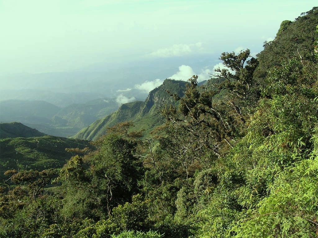
A high, misty plateau of montane grassland and cloud forest in Sri Lanka's highlands, ending abruptly at World's End — a sheer escarpment that drops nearly 900 metres to the plains.
What makes it marvelous
Horton Plains sits above 2,000 metres on Sri Lanka's central massif, a rolling plateau of tussock grassland and stunted, moss-draped cloud forest kept cool and wet by the mist. Its most dramatic feature is World's End, where the plateau simply stops: a vertical escarpment plunging close to 880 metres to the lowlands far below, often with cloud boiling up the cliff. The plains are the source of several of Sri Lanka's major rivers and part of a UNESCO-listed highland wilderness.
Why visit
The classic loop walk crosses open grassland where sambar deer graze, through cloud forest hung with moss and ferns, to the dizzying viewpoint of World's End and the pretty Baker's Falls. Reach the cliff early and you look out over half the island; arrive late and you may see only a wall of cloud. It is one of the few places you can freely walk in Sri Lanka's high wilderness.
What to know before you go
🗓️ Best time
The drier months of January to March give the clearest mornings; whatever the season, arrive at dawn — World's End usually clouds over by mid-morning.
🧭 Getting there & access
In the central highlands near Nuwara Eliya and the hill-country town of Ohiya. A ticketed national park with a marked circular trail of about 9 kilometres to World's End and Baker's Falls; an early start is essential for the view.
Good to know
- Enter at opening (around dawn) to reach World's End before the cloud rolls in.
- Bring warm layers — the highland mornings are genuinely cold, unlike the coast.
- Carry out all litter and don't bring plastic bottles; the park is strict to protect the ecosystem.
Plan your visit
Moderate🧭 Getting there
From Colombo (CMB), then Nuwara Eliya
- Fly to Colombo
- Train or road up to Nuwara Eliya or Ohiya in the hill country — a scenic 5–6h from Colombo
- Early-morning transfer to the park entrance, then the walking loop
- Total travel
- A full day from the hill-country towns; longer from the coast
- Time at site
- 3–4 hours for the 9 km loop to World's End and Baker's Falls
- Access
- National park ticket (higher for foreign visitors), with a plastic and littering ban enforced at the gate. The circular trail is one-way and best walked clockwise; go at opening for any chance of the World's End view.
🎒 What to bring & consider
- Warm and waterproof layers — cold, wet, and misty even in the dry season
- Sturdy walking shoes for the uneven, sometimes boggy trail
- Water and snacks (no plastic bottles past the gate — decant into reusables)
- An early alarm; the whole trip hinges on a dawn start
👁️ What to expect
- Crowds
- Steady from mid-morning at World's End; the earliest walkers often have the cliff to themselves.
- Conditions
- A rolling 9 km trail over grassland and through forest, muddy in places, cold and misty; the cliff edge is unfenced.
- Facilities
- Ticket office and toilets at the entrance; nothing on the loop itself.
- The view
- The plains falling away at World's End with cloud rising up the cliff at dawn, or the tiered Baker's Falls. Everything depends on getting there before the mist closes in.
Times and requirements are approximate and change with season, weather, and local rules — confirm permits, fares, and schedules with operators before you travel.
Natural riches of the area
- High-altitude montane grassland and cloud forest
- The World's End escarpment and Baker's Falls
- Headwaters of major rivers, including the Mahaweli
- Endemic wildlife such as sambar deer and the purple-faced langur
Local food
- Ceylon tea
- World-famous highland tea grown on the surrounding hill-country slopes.
- Hoppers (appa)
- Bowl-shaped fermented rice-and-coconut pancakes, often with an egg.
Horton Plains is a different Sri Lanka: cold, misty highland country more than 2,000 metres up, where tussock grassland rolls between patches of stunted cloud forest dripping with moss. The plateau catches the monsoon and holds it as fog, feeding some of the island’s greatest rivers and keeping the whole landscape wet and green. Then, at its southern rim, the ground simply ends — the escarpment of World’s End dropping almost 900 vertical metres to the lowlands, a view that on a clear dawn reaches all the way to the distant coast.
The park’s circular trail takes walkers across the open grassland, where sambar deer graze in the early light, into the tangled cloud forest, and out to the great cliff before looping back past the cascade of Baker’s Falls. The catch is timing: by mid-morning cloud usually swallows the view entirely, so the reward goes to those who arrive at first light. It is a rare chance to walk freely in the high wilderness at the heart of a UNESCO-protected highland.
Horton Plains & World's End: common questions
How do you get to Horton Plains & World's End?
From Colombo (CMB), then Nuwara Eliya: Fly to Colombo; Train or road up to Nuwara Eliya or Ohiya in the hill country — a scenic 5–6h from Colombo; Early-morning transfer to the park entrance, then the walking loop. Allow a full day from the hill-country towns; longer from the coast.
When is the best time to visit Horton Plains & World's End?
The drier months of January to March give the clearest mornings; whatever the season, arrive at dawn — World's End usually clouds over by mid-morning.
How long should you spend at Horton Plains & World's End?
3–4 hours for the 9 km loop to World's End and Baker's Falls. A full day from the hill-country towns; longer from the coast of travel from Colombo (CMB), then Nuwara Eliya.
What should you bring to Horton Plains & World's End?
Warm and waterproof layers — cold, wet, and misty even in the dry season Sturdy walking shoes for the uneven, sometimes boggy trail Water and snacks (no plastic bottles past the gate — decant into reusables) An early alarm; the whole trip hinges on a dawn start
Do you need a permit or guide for Horton Plains & World's End?
National park ticket (higher for foreign visitors), with a plastic and littering ban enforced at the gate. The circular trail is one-way and best walked clockwise; go at opening for any chance of the World's End view.
Is Horton Plains & World's End crowded, and what are conditions like?
Steady from mid-morning at World's End; the earliest walkers often have the cliff to themselves. A rolling 9 km trail over grassland and through forest, muddy in places, cold and misty; the cliff edge is unfenced. Facilities: ticket office and toilets at the entrance; nothing on the loop itself.
Added
More wonders to explore