Tsingy de Bemaraha
📍 Melaky, western Madagascar
A vast 'forest of stone' — a labyrinth of razor-sharp limestone pinnacles rising in grey blades from the Madagascar wilderness, hiding canyons, caves, and creatures found nowhere else.
What makes it marvelous
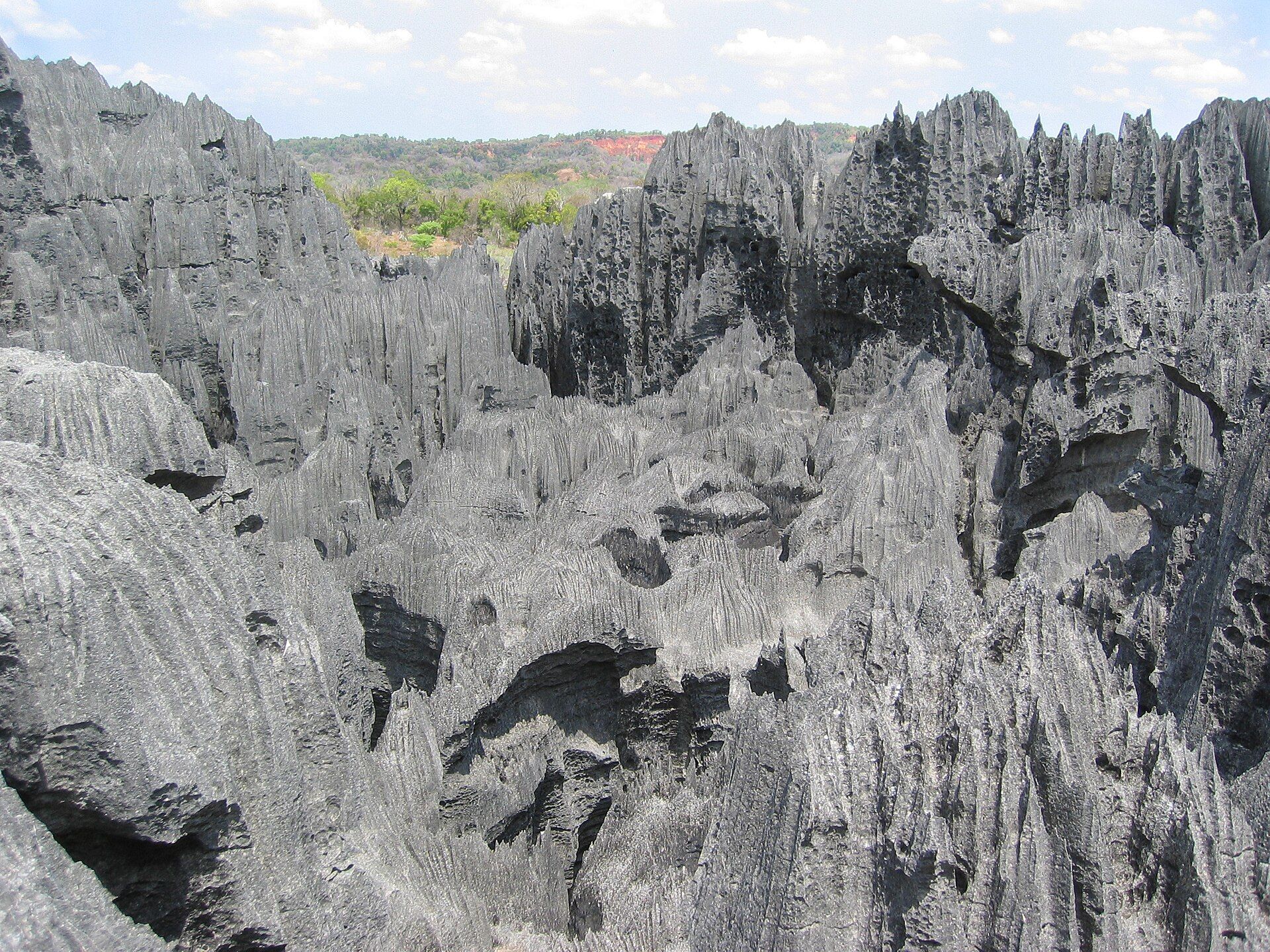
Tsingy de Bemaraha is one of the strangest landscapes on Earth: an immense field of limestone pinnacles eroded into serried, knife-edged blades that rise like a petrified forest of grey stone. Rainwater has dissolved an ancient seabed of limestone along its cracks over millions of years, cutting the rock downward into a maze of needle-sharp towers, deep slot canyons, and hidden caves — 'tsingy' means, roughly, 'where one cannot walk barefoot'. This near-impenetrable terrain shelters an ark of wildlife found only in Madagascar, including lemurs that leap between the spires, alongside rare birds, reptiles, and orchids. Explored on suspension bridges and vertiginous rope routes threaded through the stone, it is a UNESCO World Heritage Site and one of the island's most extraordinary wild places.
Why visit
Clambering through a cathedral of razor rock — across swaying bridges and up ladders between grey pinnacles, with lemurs watching from the blades — is one of the most adventurous and otherworldly wildlife experiences on the planet.
What to know before you go
🗓️ Best time
The dry season (roughly April–November), the only period the reserve is reliably accessible; the wet season floods the tracks and closes the park.
🧭 Getting there & access
In remote western Madagascar, reached by a long, rough overland journey (often via Morondava) with river crossings; access is dry-season only, on guided routes with bridges and via-ferrata-style climbs.
Good to know
- Visit only in the dry season — the wet season closes the reserve.
- Wear sturdy shoes and gloves; the rock is genuinely razor-sharp.
- Go with a licensed local guide; the routes are technical and protected.
Plan your visit
Strenuous🧭 Getting there
From Antananarivo (TNR), then Morondava
- Fly into Antananarivo
- Fly or drive to Morondava — the road journey is roughly 8–12h
- Morondava → Bekopaka — about 8–10h on very rough track with two river ferry crossings
- The tsingy massifs are a further 1–2h from Bekopaka
- Total travel
- Two days from Antananarivo by road
- Time at site
- 2–3 days based at Bekopaka
- Access
- National park entry plus a mandatory local guide, arranged at the park office. The park closes for the rainy season, roughly November to April, when the tracks become impassable — a hard closure rather than a caution. The Grand Tsingy circuits require a harness and via ferrata clipping, provided and supervised by the guides. Confirm current opening with Madagascar National Parks.
🎒 What to bring & consider
- Boots with hard soles — the tsingy is limestone eroded into blades sharp enough to cut through soft footwear and skin, and this is the single most important thing you bring
- Gloves, because you will be hauling yourself over that same rock
- The harness supplied by the park, worn exactly as instructed on the exposed circuits
- Plenty of water; the rock radiates heat and there is no shade among the pinnacles
- Patience for the access road, which is among the roughest routes visitors commonly drive anywhere
👁️ What to expect
- Crowds
- Low, limited chiefly by how hard it is to get there.
- Conditions
- Extremely sharp rock, narrow crevices, ladders, rope bridges and real exposure, in heat.
- Facilities
- Simple lodges at Bekopaka. Nothing at the massifs beyond the park office.
- The view
- The pinnacle fields read best from the via ferrata viewpoints in morning light. The Avenue of the Baobabs sits near Morondava and is normally folded into the same trip as a separate stop.
Times and requirements are approximate and change with season, weather, and local rules — confirm permits, fares, and schedules with operators before you travel.
Natural riches of the area
- A vast karst labyrinth of razor-edged limestone pinnacles
- Slot canyons, caves, and underground rivers
- Endemic lemurs, birds, reptiles, and orchids of Madagascar
- One of the island's least-disturbed wild ecosystems
Local food
- Malagasy rice
- Rice is the heart of every Malagasy meal, often with a side of greens (romazava).
- Zebu
- Grilled or stewed zebu (humped cattle), central to Malagasy cooking.
- Tropical fruit
- Mango, coconut, and other fruit of Madagascar's west.
Tsingy de Bemaraha is a forest made of stone. Across a great swathe of remote western Madagascar, limestone has been dissolved by rainwater along its cracks over millions of years and cut downward into a labyrinth of razor-edged grey pinnacles — a petrified thicket of blades, slot canyons, and hidden caves. The name ‘tsingy’ means, roughly, ‘where one cannot walk barefoot,’ and the rock is sharp enough to prove it.
This near-impenetrable maze is an ark of life. Lemurs leap between the spires, rare birds and reptiles shelter in the shadows, and orchids cling to the stone — species found only on this island continent. Visitors explore it on suspension bridges and vertiginous rope routes threaded through the rock, a genuinely adventurous passage into one of the most otherworldly landscapes on Earth. A UNESCO World Heritage Site, it is among Madagascar’s strangest and most spectacular wild places.
Tsingy de Bemaraha: common questions
How do you get to Tsingy de Bemaraha?
From Antananarivo (TNR), then Morondava: Fly into Antananarivo; Fly or drive to Morondava — the road journey is roughly 8–12h; Morondava → Bekopaka — about 8–10h on very rough track with two river ferry crossings; The tsingy massifs are a further 1–2h from Bekopaka. Allow Two days from Antananarivo by road.
When is the best time to visit Tsingy de Bemaraha?
The dry season (roughly April–November), the only period the reserve is reliably accessible; the wet season floods the tracks and closes the park.
How long should you spend at Tsingy de Bemaraha?
2–3 days based at Bekopaka. Two days from Antananarivo by road of travel from Antananarivo (TNR), then Morondava.
What should you bring to Tsingy de Bemaraha?
Boots with hard soles — the tsingy is limestone eroded into blades sharp enough to cut through soft footwear and skin, and this is the single most important thing you bring Gloves, because you will be hauling yourself over that same rock The harness supplied by the park, worn exactly as instructed on the exposed circuits Plenty of water; the rock radiates heat and there is no shade among the pinnacles Patience for the access road, which is among the roughest routes visitors commonly drive anywhere
Do you need a permit or guide for Tsingy de Bemaraha?
National park entry plus a mandatory local guide, arranged at the park office. The park closes for the rainy season, roughly November to April, when the tracks become impassable — a hard closure rather than a caution. The Grand Tsingy circuits require a harness and via ferrata clipping, provided and supervised by the guides. Confirm current opening with Madagascar National Parks.
Is Tsingy de Bemaraha crowded, and what are conditions like?
Low, limited chiefly by how hard it is to get there. Extremely sharp rock, narrow crevices, ladders, rope bridges and real exposure, in heat. Facilities: simple lodges at Bekopaka. Nothing at the massifs beyond the park office.
Added
More wonders to explore