The Yucatán Cenotes
📍 Yucatán Peninsula, Mexico
Thousands of natural sinkholes opening into a hidden world of crystal-clear groundwater and flooded caves beneath the Yucatán — sacred to the ancient Maya and among the most beautiful swimming holes on Earth.
What makes it marvelous
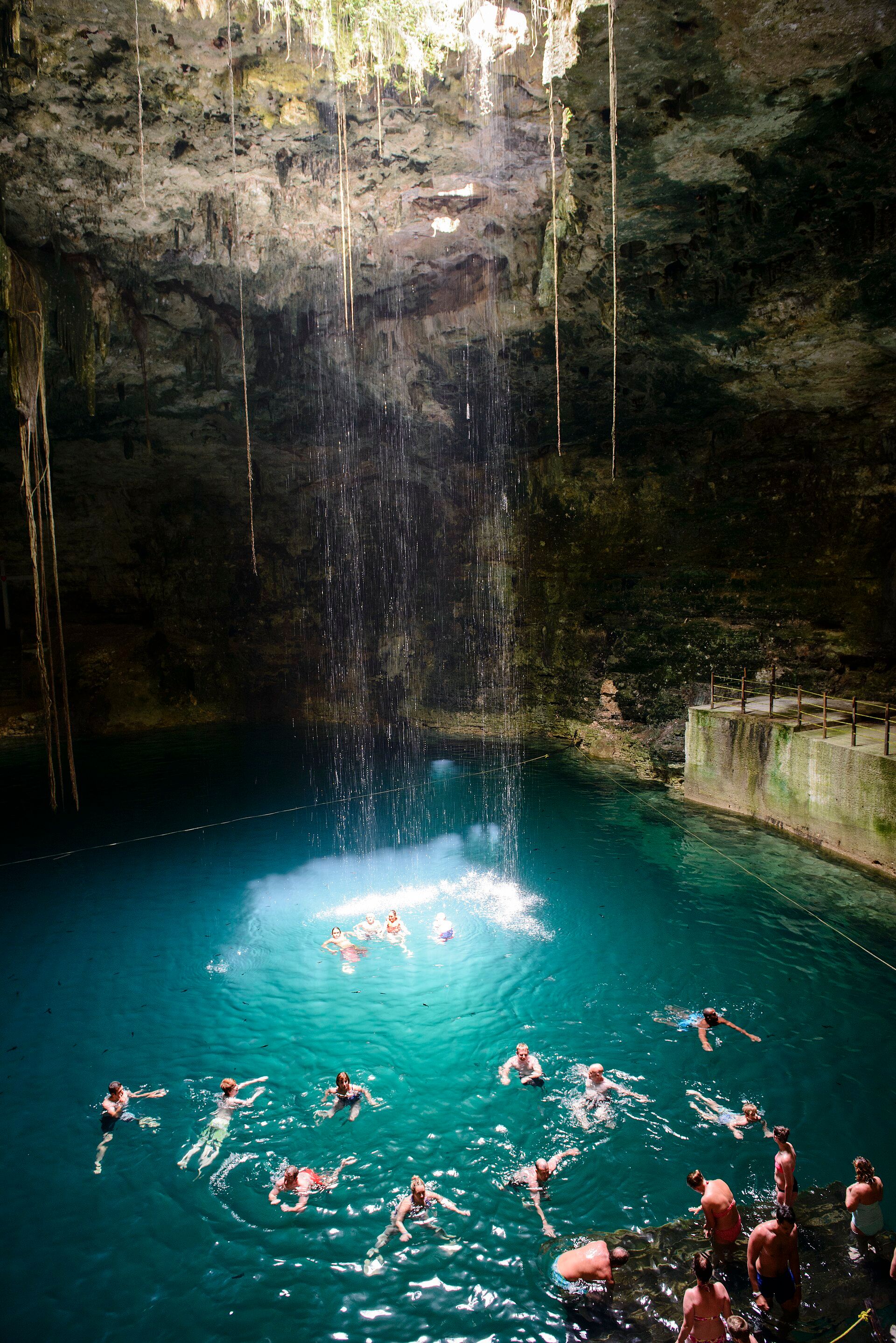
Cenotes are sinkholes formed where the Yucatán's porous limestone collapsed to reveal the vast freshwater aquifer and cave systems beneath — part of some of the longest underwater cave networks in the world. The water is astonishingly clear and cool, often lit by shafts of sunlight through an opening in the rock, with tree roots trailing down and stalactites overhead. Many cenotes lie along a great arc, the 'Ring of Cenotes', that traces the buried rim of the Chicxulub crater — the impact that helped end the age of the dinosaurs. To the ancient Maya they were sacred wells and gateways to the underworld.
Why visit
Swimming or diving in a cenote — floating in glass-clear water beneath a cathedral of rock and roots, sunbeams cutting the blue — is unforgettable. They range from open pools to deep cave dives, and dot the jungle across the peninsula near Maya ruins and the Riviera Maya.
What to know before you go
🗓️ Best time
Year-round (the water stays cool and clear); the drier months (roughly November–April) are most comfortable and less crowded than peak holidays.
🧭 Getting there & access
Across the Yucatán Peninsula, especially around Tulum, Valladolid, and Mérida in Mexico. Many are developed for swimming; cave and cavern diving require certified guides.
Good to know
- Rinse off sunscreen and cosmetics before entering — they harm the fragile water.
- Cave diving is for trained, certified divers only, always with a guide.
- Go early to have the more popular cenotes to yourself.
Plan your visit
Easy🧭 Getting there
From Cancún, Playa del Carmen, Tulum or Valladolid, Mexico
- Fly → Cancún (CUN)
- Drive or shuttle Cancún → Tulum — roughly 1h45–2h30 depending on traffic on Highway 307
- Drive Tulum → the Dos Ojos and Gran Cenote cluster — 10–30 minutes
- Valladolid → the inland cenotes around Cuzamá and Homún — about 1h30–2h
- Total travel
- Around two hours from the airport to the first cenote
- Time at site
- Two or three cenotes in a day is plenty; more than that and they blur
- Access
- Cenotes are not a single park. Many sit on ejido or private land, and each community sets its own entry fee, opening hours and rules independently — which is exactly why no figure quoted online stays right for long. Ask at the gate. Cavern diving inside the daylight zone is open to certified divers with a guide; going past the permanent line into true cave requires full cave certification, and the memorials at some entrances are there for people who ignored that.
🎒 What to bring & consider
- No sunscreen, no insect repellent, no make-up — you will be asked to shower first, and it is not a formality. These are the drinking water aquifer for the peninsula and the chemicals do not flush out
- Water shoes for slick limestone steps and rock that is sharp where it is not slippery
- A thin wetsuit or rashguard if you are in for more than a quick swim: the water sits around 24–25°C year-round, which feels cold after the Caribbean
- Cash in pesos in small notes, because gate fees at village-run cenotes are cash and change is limited
- A torch for the darker cavern systems, and a guide if you want to go anywhere beyond the open pool
👁️ What to expect
- Crowds
- The famous ones near Tulum and along the Highway 307 corridor fill with tour buses from mid-morning. Go at opening, or drive inland toward Homún where the same geology comes without the queue.
- Conditions
- Cool, still, startlingly clear fresh water. Some are open sinkholes with sunlight; others are ladder-access caves in near darkness. Steps are steep and wet.
- Facilities
- Varies enormously — from full changing rooms and restaurants to a hut, a ladder and a life jacket.
- The view
- A single shaft of midday light dropping through the roof opening into blue water. It needs sun, and it needs the middle of the day, which is also when the crowds are worst — that trade-off is the whole photographic problem here.
Times and requirements are approximate and change with season, weather, and local rules — confirm permits, fares, and schedules with operators before you travel.
Natural riches of the area
- Vast limestone aquifer and among the longest underwater cave systems on Earth
- Crystal-clear freshwater sinkholes (cenotes)
- The Chicxulub-impact 'Ring of Cenotes'
- Jungle ecosystems and the peninsula's sole freshwater source
Local food
- Cochinita pibil
- Yucatán's slow-roasted, achiote-marinated pork, wrapped in banana leaf.
- Sopa de lima
- A tangy lime-and-chicken soup, a peninsula classic.
- Papadzules
- Tortillas in pumpkin-seed sauce, a traditional Maya dish.
Beneath the flat jungle of the Yucatán hides a second, watery world. Where the porous limestone has collapsed, thousands of sinkholes — cenotes — open into the vast freshwater aquifer and cave systems below, some among the longest underwater caves on the planet. The water is glass-clear and cool, often lit by a single shaft of sunlight falling through a hole in the rock, with tree roots trailing down and stalactites hanging above.
The cenotes hold deep history, too. Many follow a great arc known as the Ring of Cenotes, which traces the buried rim of the Chicxulub crater — the asteroid impact that helped end the age of the dinosaurs. To the ancient Maya, for whom they were the peninsula’s only water source, they were sacred wells and doorways to the underworld. To swim in one today, floating in blue light beneath a cathedral of stone and roots, is to drop into one of the most beautiful hidden places on Earth.
The Yucatán Cenotes: common questions
How do you get to The Yucatán Cenotes?
From Cancún, Playa del Carmen, Tulum or Valladolid, Mexico: Fly → Cancún (CUN); Drive or shuttle Cancún → Tulum — roughly 1h45–2h30 depending on traffic on Highway 307; Drive Tulum → the Dos Ojos and Gran Cenote cluster — 10–30 minutes; Valladolid → the inland cenotes around Cuzamá and Homún — about 1h30–2h. Allow Around two hours from the airport to the first cenote.
When is the best time to visit The Yucatán Cenotes?
Year-round (the water stays cool and clear); the drier months (roughly November–April) are most comfortable and less crowded than peak holidays.
How long should you spend at The Yucatán Cenotes?
Two or three cenotes in a day is plenty; more than that and they blur. Around two hours from the airport to the first cenote of travel from Cancún, Playa del Carmen, Tulum or Valladolid, Mexico.
What should you bring to The Yucatán Cenotes?
No sunscreen, no insect repellent, no make-up — you will be asked to shower first, and it is not a formality. These are the drinking water aquifer for the peninsula and the chemicals do not flush out Water shoes for slick limestone steps and rock that is sharp where it is not slippery A thin wetsuit or rashguard if you are in for more than a quick swim: the water sits around 24–25°C year-round, which feels cold after the Caribbean Cash in pesos in small notes, because gate fees at village-run cenotes are cash and change is limited A torch for the darker cavern systems, and a guide if you want to go anywhere beyond the open pool
Do you need a permit or guide for The Yucatán Cenotes?
Cenotes are not a single park. Many sit on ejido or private land, and each community sets its own entry fee, opening hours and rules independently — which is exactly why no figure quoted online stays right for long. Ask at the gate. Cavern diving inside the daylight zone is open to certified divers with a guide; going past the permanent line into true cave requires full cave certification, and the memorials at some entrances are there for people who ignored that.
Is The Yucatán Cenotes crowded, and what are conditions like?
The famous ones near Tulum and along the Highway 307 corridor fill with tour buses from mid-morning. Go at opening, or drive inland toward Homún where the same geology comes without the queue. Cool, still, startlingly clear fresh water. Some are open sinkholes with sunlight; others are ladder-access caves in near darkness. Steps are steep and wet. Facilities: varies enormously — from full changing rooms and restaurants to a hut, a ladder and a life jacket.
Added
More wonders to explore