Bardenas Reales
📍 Navarre, northern Spain
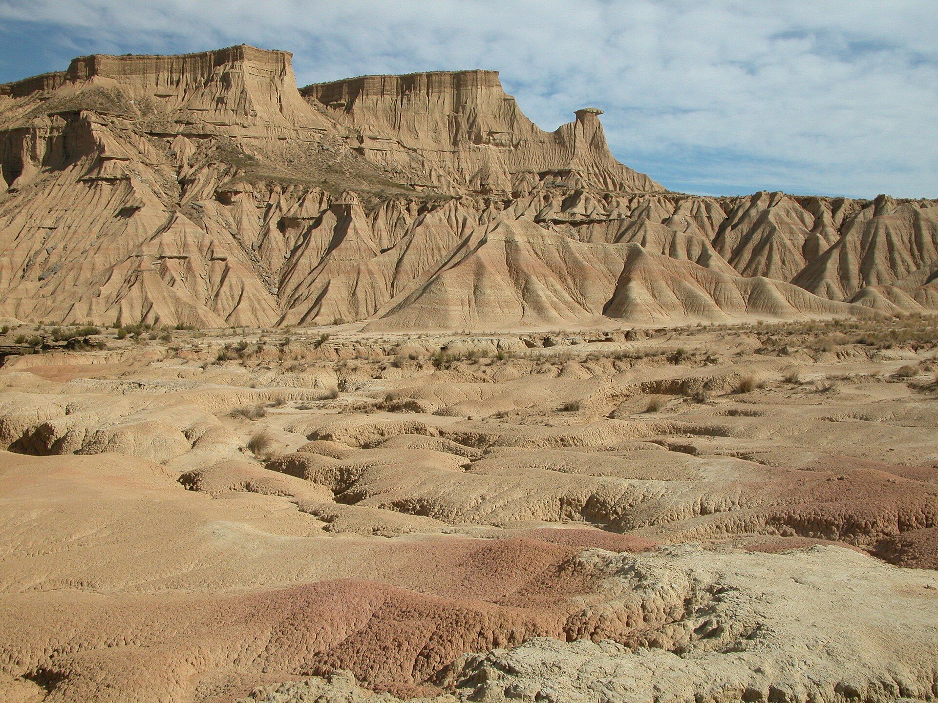
A semi-desert of pale clay badlands in northern Spain — wind- and water-carved ravines, flat-topped mesas, and lone earth pillars that look transplanted from the American West.
What makes it marvelous
The Bardenas Reales is a badlands of soft clay, chalk, and sandstone laid down by ancient lakes and rivers, then stripped by seasonal rains and dry winds into gullies, plateaus, and isolated hills. Its emblem is Castildetierra, a solitary earth pillar capped by a harder layer that has protected the softer clay beneath it from eroding away. Almost treeless and strikingly arid for green northern Spain, it is a UNESCO Biosphere Reserve.
Why visit
Driving or cycling the dusty tracks across the Bardenas feels like crossing a film-set desert — pale ravines, wind-cut mesas, and the famous finger of Castildetierra rising from the flats. It is one of the largest natural deserts in Europe, home to steppe birds and, at dawn and dusk, a landscape that glows gold and takes on long dramatic shadows.
What to know before you go
🗓️ Best time
Spring and autumn are most comfortable; summer is fiercely hot and dry, and heavy rain can make the clay tracks briefly impassable. Early morning and late afternoon give the best light.
🧭 Getting there & access
In southeast Navarre, reached from Tudela or Arguedas. A public information centre marks the entrance; a network of unpaved tracks (open to cars, bikes, and walkers) crosses the reserve, with some areas restricted to protect wildlife.
Good to know
- Fill up on water and fuel first — there are no services inside the reserve.
- Check the weather; the clay roads turn to sticky mud and can close after heavy rain.
- Stick to open tracks and respect the fenced military and wildlife-restricted zones.
Plan your visit
Easy🧭 Getting there
From Zaragoza (ZAZ) or Pamplona (PNA), northern Spain
- Fly to Zaragoza or Pamplona, or drive from Bilbao or Madrid
- Road to Tudela or Arguedas at the reserve's edge — about 1h30 from either city
- Enter at the information centre; tracks fan out across the badlands from there
- Total travel
- Half a day from the nearby cities
- Time at site
- Half a day to drive or cycle the main loop; longer to walk and photograph
- Access
- Free to enter along the marked tracks during daylight hours. Parts are a live military range and are closed on firing days, and some zones are off-limits for wildlife — signs and the information centre set out where you can go.
🎒 What to bring & consider
- Plenty of water and sun protection — there is no shade and it gets very hot
- A full tank and no reliance on services inside the reserve
- Sturdy shoes; the clay is dusty when dry and slick when wet
- A vehicle you don't mind getting dusty, or a bike for the flatter tracks
👁️ What to expect
- Crowds
- Quiet compared with Spain's headline sights; busier at weekends and around Castildetierra, but easy to find solitude.
- Conditions
- Flat, dusty unpaved tracks under open sky — easy going in dry weather, awkward after rain.
- Facilities
- An information centre and a campsite at the edge; nothing inside. Towns nearby for food and fuel.
- The view
- Castildetierra's lone pillar at sunrise or sunset, when low light rakes across the ravines. Overcast days flatten the badlands, so aim for the golden hours.
Times and requirements are approximate and change with season, weather, and local rules — confirm permits, fares, and schedules with operators before you travel.
Natural riches of the area
- Eroded clay, gypsum, and sandstone badlands
- Isolated earth pillars and flat-topped mesas (cabezos)
- Semi-arid steppe habitat for larks, sandgrouse, and birds of prey
- Seasonal watercourses that carve the ravines
Local food
- Piquillo peppers
- Sweet roasted red peppers, a prized specialty of Navarre.
- Cordero al chilindrón
- Lamb braised with peppers and tomato, a classic of the region.
The Bardenas Reales is a piece of desert that feels out of place in green, rainy northern Spain: some 400 square kilometres of pale, treeless badlands carved from the soft clay, chalk, and sandstone of ancient lake beds. Seasonal downpours and dry winds have stripped the ground into a maze of ravines, flat-topped mesas, and lone hills, the whole scene washed in dusty ochres and greys. It is one of the largest natural deserts in Europe, and its emptiness is exactly the point.
Its most photographed feature is Castildetierra, a slender pillar of clay standing alone on the plain, protected from erosion by a cap of harder rock while the ground around it wore away. A UNESCO Biosphere Reserve, the Bardenas is also important for steppe wildlife — larks, sandgrouse, and raptors that thrive in the arid open country. Crossed by a web of dusty tracks open to cars, bikes, and walkers, it rewards an early start, when the low sun sets the ravines glowing.
Bardenas Reales: common questions
How do you get to Bardenas Reales?
From Zaragoza (ZAZ) or Pamplona (PNA), northern Spain: Fly to Zaragoza or Pamplona, or drive from Bilbao or Madrid; Road to Tudela or Arguedas at the reserve's edge — about 1h30 from either city; Enter at the information centre; tracks fan out across the badlands from there. Allow Half a day from the nearby cities.
When is the best time to visit Bardenas Reales?
Spring and autumn are most comfortable; summer is fiercely hot and dry, and heavy rain can make the clay tracks briefly impassable. Early morning and late afternoon give the best light.
How long should you spend at Bardenas Reales?
Half a day to drive or cycle the main loop; longer to walk and photograph. Half a day from the nearby cities of travel from Zaragoza (ZAZ) or Pamplona (PNA), northern Spain.
What should you bring to Bardenas Reales?
Plenty of water and sun protection — there is no shade and it gets very hot A full tank and no reliance on services inside the reserve Sturdy shoes; the clay is dusty when dry and slick when wet A vehicle you don't mind getting dusty, or a bike for the flatter tracks
Do you need a permit or guide for Bardenas Reales?
Free to enter along the marked tracks during daylight hours. Parts are a live military range and are closed on firing days, and some zones are off-limits for wildlife — signs and the information centre set out where you can go.
Is Bardenas Reales crowded, and what are conditions like?
Quiet compared with Spain's headline sights; busier at weekends and around Castildetierra, but easy to find solitude. Flat, dusty unpaved tracks under open sky — easy going in dry weather, awkward after rain. Facilities: an information centre and a campsite at the edge; nothing inside. Towns nearby for food and fuel.
Added
More wonders to explore