Blue Nile Falls
📍 Amhara, northern Ethiopia
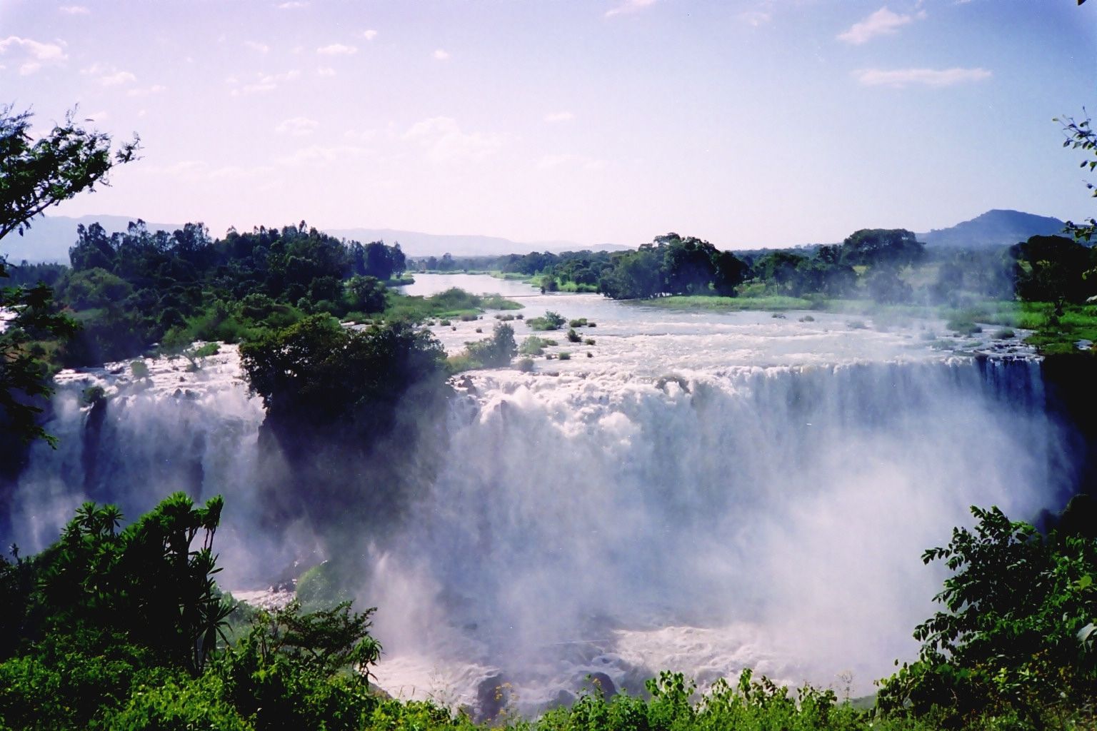
'The Great Smoke' — a broad curtain of water thundering off the Ethiopian plateau near the source of the Blue Nile, throwing up mist and rainbows in the rainy season.
What makes it marvelous
Not far from where the Blue Nile leaves Lake Tana, the river reaches the edge of the Ethiopian plateau and drops some 40 metres over a broad basalt lip, spreading into a thundering curtain up to 400 metres wide in full flow. Ethiopians call it Tis Abay — 'the great smoke' — for the spray it hurls into the air, which drifts over the surrounding fields, catches the sun in rainbows, and keeps a pocket of green forest alive on the gorge walls. The falls mark the beginning of the Blue Nile's long journey north, and this river supplies the great majority of the Nile's water and nearly all of its fertile silt, making these highlands the true engine of the river that built Egypt. The volume swings dramatically with the rains, and in the wet season the falls are at their most spectacular.
Why visit
Walking across the old stone bridge and up through the fields to watch the Blue Nile crash off the plateau in a wall of spray — near the very headwaters of the world's most storied river — is both scenic and quietly profound.
What to know before you go
🗓️ Best time
The rainy season and just after (roughly September–October, with high flow from June onward), when the falls are broad and thunderous; the dry season can reduce them considerably.
🧭 Getting there & access
About 30 km from Bahir Dar in northern Ethiopia, reached by road then a short walk through farmland and over a historic stone bridge; local guides accompany visitors from the nearby village.
Good to know
- Visit after the rains (Sept–Oct) for the fullest, most dramatic flow.
- Wear shoes with grip — the path can be muddy and slick with spray.
- Hire a local village guide; it supports the community directly.
Plan your visit
Easy🧭 Getting there
From Bahir Dar, Amhara, Ethiopia
- Fly Addis Ababa → Bahir Dar (BJR) — roughly 1h
- Drive Bahir Dar → Tis Abay village — about 45 minutes to an hour on a paved road
- Walk from the village to the viewpoints, crossing the river — roughly 30–45 minutes each way
- Total travel
- A half-day trip from Bahir Dar
- Time at site
- Two to three hours on the loop walk
- Access
- A local entry fee is collected at Tis Abay village, and hiring one of the local guides is expected and worthwhile on the unmarked loop. The single biggest variable is water: an upstream hydroelectric scheme diverts much of the flow, so the falls are a fraction of their old selves for stretches of the year and thunder only when the river is high or water is being released. The volume is best in and just after the main rains. Ask locally in Bahir Dar what the falls are doing before you commit the morning.
🎒 What to bring & consider
- Honest expectations about flow — in the dry months a diversion upstream can leave a thin curtain where the guidebooks show a wall of water, and the rains are when it earns its name of "the smoking water"
- Grippy footwear for a path that is genuinely slippery on the spray-wet basalt and the stones by the river crossing
- Small notes for the entry fee, the guide and the boatman at the river crossing
- Sun protection for an exposed walk with little shade
- A dry bag or cover for a camera, because the mist reaches the best viewpoint
👁️ What to expect
- Crowds
- Modest. A steady trickle of visitors rather than crowds, busier at weekends.
- Conditions
- A short but up-and-down walk on dirt paths, with a river to cross by boat or the old Portuguese bridge.
- Facilities
- Basic — the village has drinks and snacks, little else. Bring what you need.
- The view
- The full curtain seen from the main viewpoint across the gorge, with the spray rainbow in morning light. It only exists as pictured when the river is up, which is the whole reason to check the flow before you go.
Times and requirements are approximate and change with season, weather, and local rules — confirm permits, fares, and schedules with operators before you travel.
Natural riches of the area
- A ~40 m falls up to 400 m wide in full flow
- The headwaters of the Blue Nile, from Lake Tana
- Spray-fed gorge forest and rainbows
- The source of most of the Nile's water and fertile silt
Local food
- Injera with wat
- Ethiopia's sourdough flatbread with spiced stews, eaten communally.
- Lake Tana fish
- Fresh tilapia from the nearby lake, grilled or in stews at Bahir Dar.
- Ethiopian coffee
- Prepared in the traditional ceremony — coffee's original homeland.
Shortly after the Blue Nile flows out of Lake Tana, it reaches the rim of the Ethiopian plateau and hurls itself off — some 40 metres down a broad basalt lip, spreading in full flood into a curtain up to 400 metres wide. Ethiopians know it as Tis Abay, ‘the great smoke,’ for the spray it throws into the air, which drifts across the surrounding fields, splits the sunlight into rainbows, and keeps a ribbon of green forest alive along the gorge.
There is history in that water as well as drama. These falls mark the start of the Blue Nile’s long journey north, and this single river supplies the great majority of the Nile’s water and nearly all of the fertile silt that built Egypt. To walk over the old stone bridge and up through the farmland to watch it thunder off the plateau is to stand at the engine room of the most storied river on Earth.
Blue Nile Falls: common questions
How do you get to Blue Nile Falls?
From Bahir Dar, Amhara, Ethiopia: Fly Addis Ababa → Bahir Dar (BJR) — roughly 1h; Drive Bahir Dar → Tis Abay village — about 45 minutes to an hour on a paved road; Walk from the village to the viewpoints, crossing the river — roughly 30–45 minutes each way. Allow a half-day trip from bahir dar.
When is the best time to visit Blue Nile Falls?
The rainy season and just after (roughly September–October, with high flow from June onward), when the falls are broad and thunderous; the dry season can reduce them considerably.
How long should you spend at Blue Nile Falls?
Two to three hours on the loop walk. A half-day trip from Bahir Dar of travel from Bahir Dar, Amhara, Ethiopia.
What should you bring to Blue Nile Falls?
Honest expectations about flow — in the dry months a diversion upstream can leave a thin curtain where the guidebooks show a wall of water, and the rains are when it earns its name of "the smoking water" Grippy footwear for a path that is genuinely slippery on the spray-wet basalt and the stones by the river crossing Small notes for the entry fee, the guide and the boatman at the river crossing Sun protection for an exposed walk with little shade A dry bag or cover for a camera, because the mist reaches the best viewpoint
Do you need a permit or guide for Blue Nile Falls?
A local entry fee is collected at Tis Abay village, and hiring one of the local guides is expected and worthwhile on the unmarked loop. The single biggest variable is water: an upstream hydroelectric scheme diverts much of the flow, so the falls are a fraction of their old selves for stretches of the year and thunder only when the river is high or water is being released. The volume is best in and just after the main rains. Ask locally in Bahir Dar what the falls are doing before you commit the morning.
Is Blue Nile Falls crowded, and what are conditions like?
Modest. A steady trickle of visitors rather than crowds, busier at weekends. A short but up-and-down walk on dirt paths, with a river to cross by boat or the old Portuguese bridge. Facilities: basic — the village has drinks and snacks, little else. Bring what you need.
Added Updated
More wonders to explore