Cappadocia
📍 Central Anatolia, Turkey
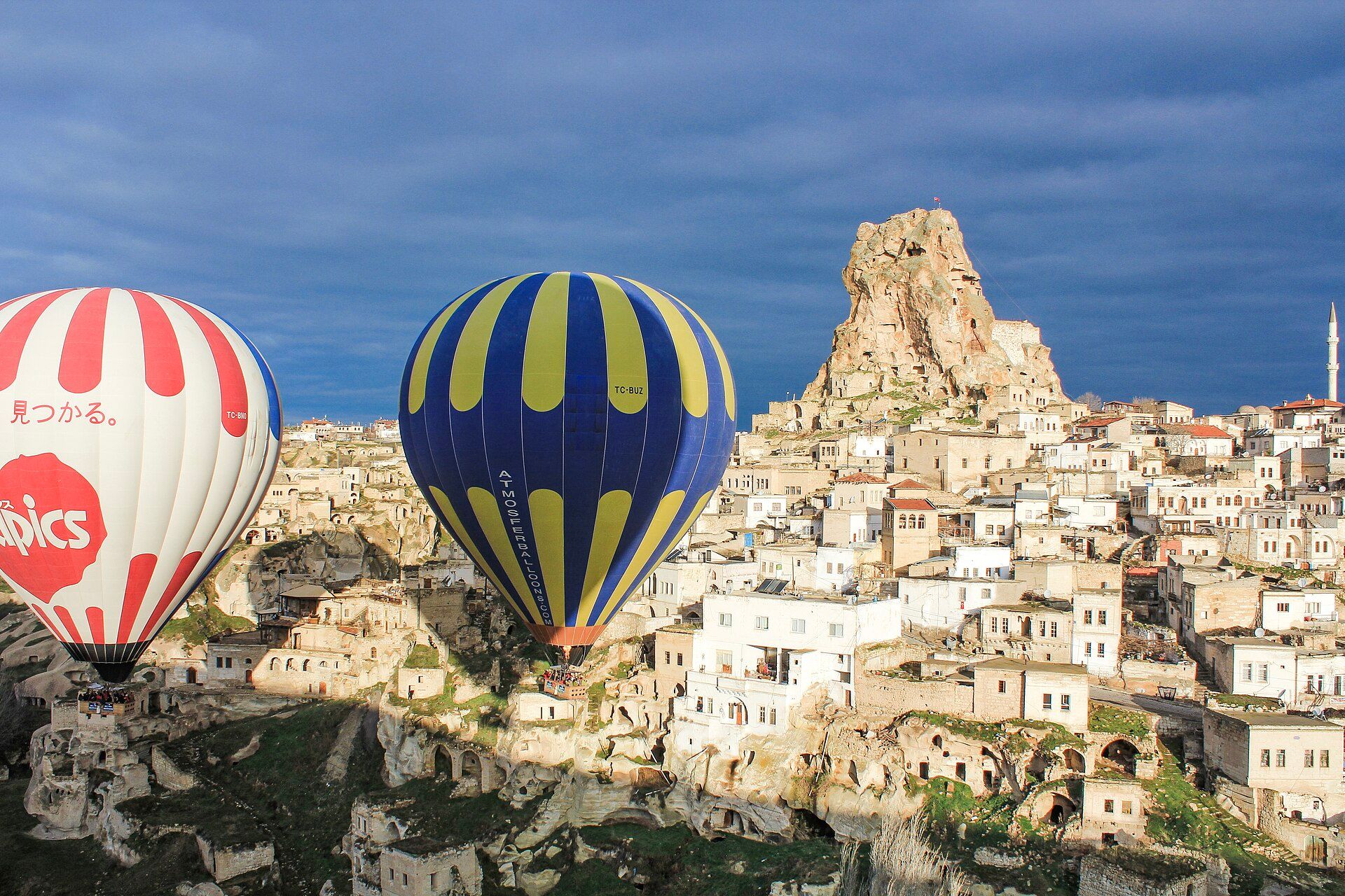
A dreamlike landscape of 'fairy chimneys' — tapering cones and pinnacles of soft volcanic rock carved by erosion, honeycombed with ancient cave homes and churches, and famous for its dawn balloon flights.
What makes it marvelous
Millions of years ago, eruptions blanketed central Anatolia in soft volcanic ash that hardened into 'tuff', often capped by a harder layer of rock. Wind and water then wore the tuff into thousands of tapering cones, pillars, and pinnacles — the 'fairy chimneys' — while the caps protected the columns beneath. Because the rock is soft, people carved into it for millennia, hollowing out cave dwellings, rock-cut churches with frescoes, and entire underground cities that sheltered thousands. It is a UNESCO World Heritage landscape of geology and human ingenuity intertwined.
Why visit
Drifting over the valleys of fairy chimneys at sunrise in a hot-air balloon — dozens of others rising with you in the golden light — is one of the world's iconic travel experiences. On the ground, hiking the rose-hued valleys and exploring cave churches and underground cities is just as extraordinary.
More views of Cappadocia
Additional photographs of the actual site — each freely licensed, with its photographer and licence credited.
What to know before you go
🗓️ Best time
Spring (April–June) and autumn (September–October) for mild weather and reliable balloon flights; summer is hot and winter can be snowy (though snow-dusted chimneys are beautiful).
🧭 Getting there & access
From Nevşehir or Kayseri airports in central Turkey, based in towns like Göreme. Balloon flights, valley hikes, and cave hotels are the classic ways to experience it.
Good to know
- Book balloon flights ahead; they fly at dawn, weather permitting.
- Spring and autumn give the best mix of mild weather and flying days.
- Explore the underground cities and rock-cut churches with a guide.
Plan your visit
Easy🧭 Getting there
From Nevsehir (NAV) or Kayseri (ASR), for Goreme
- Fly Istanbul → Nevsehir or Kayseri — roughly 1h15–1h30
- Shuttle to Goreme — about 45 minutes from Nevsehir, 1h15 from Kayseri
- Total travel
- Half a day from Istanbul
- Time at site
- 2–3 days, deliberately allowing for a balloon flight that may not fly
- Access
- The valleys are open access; the Goreme Open Air Museum and the underground cities charge entry. Balloon flights are regulated and grounded by the civil aviation authority in wind or poor visibility — cancellation is common and is not an operator trick, so keep spare mornings rather than booking your last one.
🎒 What to bring & consider
- Warm layers for the pre-dawn balloon launch, which is genuinely cold even in midsummer
- Shoes with grip — volcanic tuff is dusty and slips underfoot on the valley trails
- A torch for the underground cities, which are dim, low and long
- A tolerance for confined spaces, or a plan to skip the underground cities, where passages are narrow and stooped
- Something to keep dust off your camera in the valleys
👁️ What to expect
- Crowds
- Sunrise viewpoints fill with people watching the balloons. The valley trails just below them are largely empty.
- Conditions
- Easy walking on dusty paths. The underground cities are cramped, steep and hot.
- Facilities
- Excellent in Goreme and Urgup — accommodation, food, operators, transport.
- The view
- The balloons only fly on suitable mornings, so the famous image is simply not available on demand. Watching from a ridge costs nothing and is often better than being in a basket.
Times and requirements are approximate and change with season, weather, and local rules — confirm permits, fares, and schedules with operators before you travel.
Natural riches of the area
- Soft volcanic tuff eroded into 'fairy chimneys'
- Rock-cut cave dwellings, churches, and underground cities
- Fertile volcanic-soil valleys and vineyards
- A landscape shaped by both eruption and erosion
Local food
- Testi kebabı
- A Cappadocian stew slow-cooked and served in a sealed clay pot that's cracked open at the table.
- Manti
- Tiny Turkish dumplings in garlicky yoghurt.
- Local wine
- Cappadocia's volcanic-soil vineyards have made wine since antiquity.
Cappadocia looks like a landscape dreamed up rather than eroded into being. Ancient eruptions buried central Anatolia in soft volcanic ash that hardened into rock called tuff; where a harder cap sat on top, it sheltered the softer stone beneath as wind and water wore everything else away — leaving thousands of tapering cones and pinnacles known as fairy chimneys.
Because the rock is soft enough to dig, people made it a home for millennia, carving cave dwellings, frescoed churches, and entire underground cities where thousands could shelter. Today the most magical way to take it in is from the air: at dawn, hot-air balloons rise by the dozen over the valleys as the low sun turns the chimneys rose and gold. On foot, the painted cave churches and hidden underground cities make it a place where geology and human history are inseparable.
People didn’t just look at this landscape — they moved into it. Because the tuff is soft enough to carve yet hardens on exposure to air, generations hollowed homes, churches, and entire multi-level underground cities such as Derinkuyu into the rock, complete with ventilation shafts and stone doors that could be rolled shut. In the Göreme Open-Air Museum, rock-cut Byzantine chapels still hold centuries-old frescoes on their carved ceilings. And the modern signature of Cappadocia is aerial: on calm mornings scores of hot-air balloons lift off at first light and drift over the fairy chimneys, which is how most visitors picture the valley today.
Cappadocia: common questions
How do you get to Cappadocia?
From Nevsehir (NAV) or Kayseri (ASR), for Goreme: Fly Istanbul → Nevsehir or Kayseri — roughly 1h15–1h30; Shuttle to Goreme — about 45 minutes from Nevsehir, 1h15 from Kayseri. Allow Half a day from Istanbul.
When is the best time to visit Cappadocia?
Spring (April–June) and autumn (September–October) for mild weather and reliable balloon flights; summer is hot and winter can be snowy (though snow-dusted chimneys are beautiful).
How long should you spend at Cappadocia?
2–3 days, deliberately allowing for a balloon flight that may not fly. Half a day from Istanbul of travel from Nevsehir (NAV) or Kayseri (ASR), for Goreme.
What should you bring to Cappadocia?
Warm layers for the pre-dawn balloon launch, which is genuinely cold even in midsummer Shoes with grip — volcanic tuff is dusty and slips underfoot on the valley trails A torch for the underground cities, which are dim, low and long A tolerance for confined spaces, or a plan to skip the underground cities, where passages are narrow and stooped Something to keep dust off your camera in the valleys
Do you need a permit or guide for Cappadocia?
The valleys are open access; the Goreme Open Air Museum and the underground cities charge entry. Balloon flights are regulated and grounded by the civil aviation authority in wind or poor visibility — cancellation is common and is not an operator trick, so keep spare mornings rather than booking your last one.
Is Cappadocia crowded, and what are conditions like?
Sunrise viewpoints fill with people watching the balloons. The valley trails just below them are largely empty. Easy walking on dusty paths. The underground cities are cramped, steep and hot. Facilities: excellent in Goreme and Urgup — accommodation, food, operators, transport.
Added Updated
More wonders to explore