Mount Kinabalu
📍 Sabah, Borneo, Malaysia
The highest peak in Southeast Asia's island world — a granite giant on Borneo, ringed by one of the richest concentrations of plant life on Earth, from giant Rafflesia flowers to carnivorous pitcher plants.
What makes it marvelous
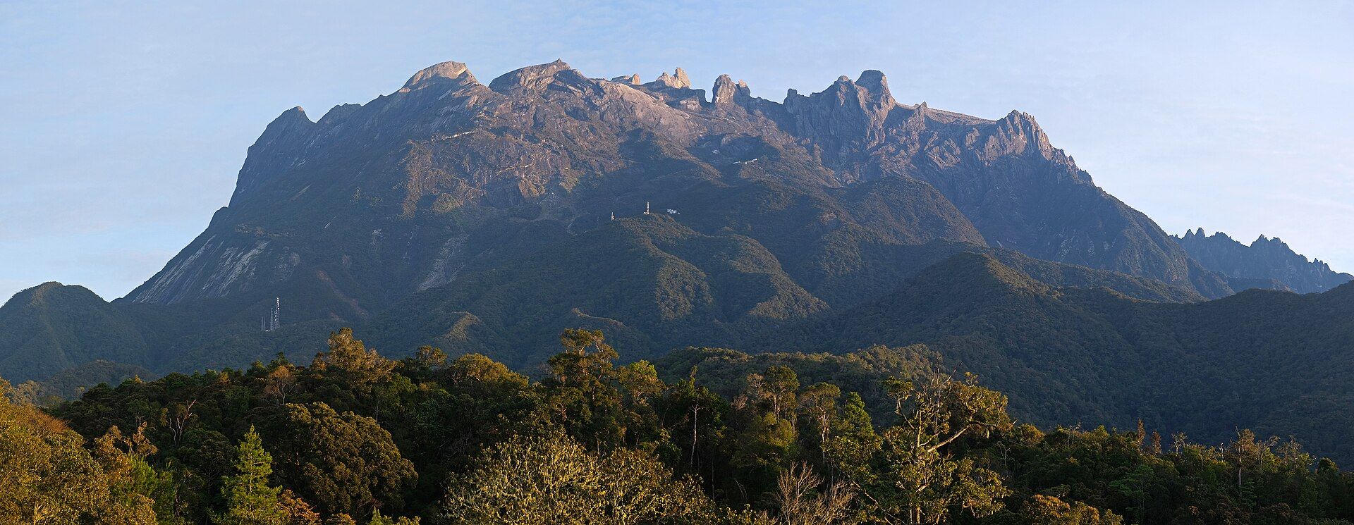
Kinabalu rises to about 4,095 metres, a young granite massif still being pushed up and, geologically recently, sculpted by ice-age glaciers whose polished rock and jagged pinnacles crown the summit plateau. Its slopes climb through lowland rainforest, montane cloud forest, and alpine scrub, packing an extraordinary range of habitats into one mountain. The result is staggering biodiversity — thousands of plant species, including the world's largest flower (Rafflesia), spectacular orchids, and endemic pitcher plants — protected in a UNESCO World Heritage park.
Why visit
It's a rare high summit that fit, non-technical climbers can reach in two days, rewarded by a dawn scramble across bare granite to watch the sun rise over Borneo far below. Even without climbing, the park's forests are a paradise for botanists and birdwatchers.
What to know before you go
🗓️ Best time
The drier months (roughly March–September) offer the best chance of clear summits; the mountain makes its own weather year-round.
🧭 Getting there & access
About two hours from Kota Kinabalu in Sabah to Kinabalu Park. The summit climb is permit- and guide-controlled with a mountain hut overnight; book well ahead as places are limited.
Good to know
- Book your climbing permit and hut far in advance — daily numbers are capped.
- Acclimatise and pace yourself; the summit is cold and high.
- Explore the park's forests for Rafflesia, orchids, and pitcher plants.
Plan your visit
Strenuous🧭 Getting there
From Kota Kinabalu (BKI), Sabah
- Fly → Kota Kinabalu (BKI)
- Road Kota Kinabalu → Kinabalu Park headquarters — roughly 2h
- Park HQ → Laban Rata — about 4h–6h of continuous stairs
- Laban Rata → summit before dawn, then all the way down — a long second day
- Total travel
- Around two hours from the airport to the park gate
- Time at site
- Two days and one night is the standard climb
- Access
- The number of climbers allowed on the mountain each day is capped, and the cap is enforced through mountain accommodation at Laban Rata — no bed, no climb. Slots are booked months ahead, particularly for weekends and holidays, and a licensed mountain guide is mandatory and assigned to your group. Permits, guide fees and accommodation are arranged through Sabah Parks and its appointed operators. The route was reshaped by the 2015 earthquake, which killed climbers on the mountain, and sections can close after seismic activity or heavy rain. Confirm with Sabah Parks.
🎒 What to bring & consider
- A confirmed Laban Rata booking months in advance, since this and not fitness is what determines whether you climb at all
- A headtorch for a summit push that starts around two in the morning to reach the plateau by sunrise
- Gloves for the fixed ropes on the bare granite slabs above the treeline, which are cold and wet before dawn
- Warm layers: the summit plateau at over 4,000m is near freezing and windy while the coast below is tropical
- Knees prepared for the descent, which drops the whole mountain in one day on relentless stone steps and is what most people actually struggle with
👁️ What to expect
- Crowds
- Capped but full — you climb with a steady stream of others and Laban Rata is a busy dormitory.
- Conditions
- Endless engineered steps through montane forest, then bare granite and fixed ropes. Cold, wet and windy up high.
- Facilities
- Excellent — park HQ, restaurants, and a heated resthouse with meals at Laban Rata.
- The view
- The granite plateau at sunrise with Low's Peak and the sea of cloud over Sabah. Cloud closes in by mid-morning almost every day, so the summit hour is the only hour.
Times and requirements are approximate and change with season, weather, and local rules — confirm permits, fares, and schedules with operators before you travel.
Natural riches of the area
- A young granite massif with glacially sculpted summit
- Exceptional plant diversity (Rafflesia, orchids, pitcher plants)
- A full forest gradient from lowland to alpine
- Endemic Bornean wildlife and montane watersheds
Local food
- Hinava
- A Sabahan raw-fish salad cured with lime — Borneo's kinilaw cousin.
- Sayur manis (Sabah veg)
- Tender local jungle greens, stir-fried.
- Tuaran mee & fresh seafood
- A Sabah noodle specialty and abundant coastal seafood.
Mount Kinabalu is Borneo’s crown — a granite peak rising to some 4,095 metres, the highest mountain in the Malay Archipelago, and still slowly being pushed skyward. Its summit plateau is bare, ice-polished rock studded with jagged pinnacles, the handiwork of glaciers that gripped the mountain in the last ice age. Climb it, as fit non-technical trekkers can over two days, and you finish with a pre-dawn scramble across the granite to watch the sun rise over the forests of Borneo far below.
But the mountain’s true wonder wraps around its flanks. Rising through lowland jungle, cloud forest, and alpine scrub, Kinabalu packs a huge range of habitats into one slope, and with them one of the richest plant communities on Earth — thousands of species, including the giant Rafflesia (the world’s largest flower), dazzling orchids, and carnivorous pitcher plants found nowhere else. It is a UNESCO World Heritage park where a great summit and a botanical treasure-house share the same mountain.
Mount Kinabalu: common questions
How do you get to Mount Kinabalu?
From Kota Kinabalu (BKI), Sabah: Fly → Kota Kinabalu (BKI); Road Kota Kinabalu → Kinabalu Park headquarters — roughly 2h; Park HQ → Laban Rata — about 4h–6h of continuous stairs; Laban Rata → summit before dawn, then all the way down — a long second day. Allow Around two hours from the airport to the park gate.
When is the best time to visit Mount Kinabalu?
The drier months (roughly March–September) offer the best chance of clear summits; the mountain makes its own weather year-round.
How long should you spend at Mount Kinabalu?
Two days and one night is the standard climb. Around two hours from the airport to the park gate of travel from Kota Kinabalu (BKI), Sabah.
What should you bring to Mount Kinabalu?
A confirmed Laban Rata booking months in advance, since this and not fitness is what determines whether you climb at all A headtorch for a summit push that starts around two in the morning to reach the plateau by sunrise Gloves for the fixed ropes on the bare granite slabs above the treeline, which are cold and wet before dawn Warm layers: the summit plateau at over 4,000m is near freezing and windy while the coast below is tropical Knees prepared for the descent, which drops the whole mountain in one day on relentless stone steps and is what most people actually struggle with
Do you need a permit or guide for Mount Kinabalu?
The number of climbers allowed on the mountain each day is capped, and the cap is enforced through mountain accommodation at Laban Rata — no bed, no climb. Slots are booked months ahead, particularly for weekends and holidays, and a licensed mountain guide is mandatory and assigned to your group. Permits, guide fees and accommodation are arranged through Sabah Parks and its appointed operators. The route was reshaped by the 2015 earthquake, which killed climbers on the mountain, and sections can close after seismic activity or heavy rain. Confirm with Sabah Parks.
Is Mount Kinabalu crowded, and what are conditions like?
Capped but full — you climb with a steady stream of others and Laban Rata is a busy dormitory. Endless engineered steps through montane forest, then bare granite and fixed ropes. Cold, wet and windy up high. Facilities: excellent — park HQ, restaurants, and a heated resthouse with meals at Laban Rata.
Added
More wonders to explore