Pangong Tso
📍 Ladakh, India
A vast high-altitude lake on the Tibetan Plateau whose waters shift through unearthly blues and greens beneath the bare, colossal mountains of Ladakh at over 4,300 metres.
What makes it marvelous
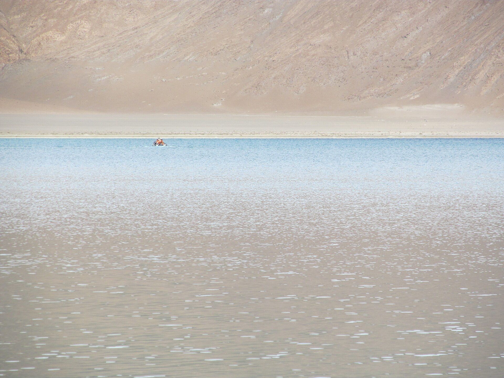
Pangong Tso stretches for some 130 kilometres across the roof of the world at an altitude of about 4,350 metres, straddling the border of Ladakh and Tibet. It is a lake of astonishing, changeable colour — its waters shift from deep blue to turquoise to green as the light and sky move over them, set against stark, treeless mountains in shades of ochre, purple, and brown. Though fed by snowmelt, it is brackish, and in the ferocious cold of a Ladakhi winter the entire high lake freezes solid. There is almost nothing here but water, rock, light, and immense silence — a landscape of high-desert emptiness so vivid it feels otherworldly, and one of the defining sights of the Indian Himalaya.
Why visit
Arriving at Pangong after crossing some of the world's highest motorable passes — to find that impossible expanse of colour-shifting water beneath bare giant mountains — is a breathtaking payoff and the emblematic image of a Ladakh journey.
What to know before you go
🗓️ Best time
Summer to early autumn (roughly May–September), when the high passes into Ladakh are open and the weather is (relatively) mild; winter freezes the lake and blocks the roads.
🧭 Getting there & access
In eastern Ladakh, reached by road from Leh over the high Chang La pass (a long day's drive); permits are required as it lies in a sensitive border area. Basic lakeside camps offer overnight stays.
Good to know
- Acclimatize in Leh first — the lake sits above 4,300 m and altitude is serious.
- Carry the required inner-line permits for this border region.
- Nights are bitterly cold even in summer; bring serious warm layers.
Plan your visit
Moderate🧭 Getting there
From Leh (IXL), Ladakh
- Fly Delhi → Leh — roughly 1h20
- Acclimatise in Leh for two or three days before going anywhere
- Road Leh → Pangong over the Chang La pass — about 4h30–5h30 depending on road and checkpoints
- Total travel
- Most of a day from Delhi, on top of the acclimatisation days
- Time at site
- An overnight at the lake is far better than a day trip
- Access
- An Inner Line Permit for Indian nationals, and a Protected Area Permit for foreign nationals, both obtained in Leh — this is a sensitive border region and permits are checked at several points. The lake extends into Chinese-controlled territory and there are stretches you may not approach. Roads close with snow and the practical season is broadly May to September. Permit rules change; confirm with the Leh district administration.
🎒 What to bring & consider
- Two or three acclimatisation days in Leh before you drive — the pass crosses above 5,300m and altitude sickness here is common and occasionally fatal. This matters more than anything else on the list
- Serious cold gear; the lake sits around 4,200m and nights freeze even in summer
- Sun protection for extreme high-altitude UV
- Cash, since ATMs stop at Leh
- Your permits and passport, carried and produced repeatedly
👁️ What to expect
- Crowds
- Busy with Indian domestic tourism in summer, concentrated on the accessible western shore. Quieter the further along you go.
- Conditions
- A long high-altitude drive over a very high pass to basic camps. The altitude does the work here, not the walking.
- Facilities
- Tented camps and small guesthouses at Spangmik and nearby. Nothing else.
- The view
- The water shifts colour dramatically through the day with the sun angle. Thin clear air gives very strong contrast, so early and late are far kinder than the middle of the day.
Times and requirements are approximate and change with season, weather, and local rules — confirm permits, fares, and schedules with operators before you travel.
Natural riches of the area
- A 130 km high-altitude lake at ~4,350 m
- Colour-shifting brackish waters that freeze in winter
- Stark, mineral-hued Himalayan and Tibetan-plateau mountains
- High-desert wildlife including migratory birds in summer
Local food
- Thukpa & momos
- Ladakhi noodle soup and dumplings, warming fare for the cold heights.
- Skyu & tsampa
- Traditional Ladakhi barley-based dishes suited to high altitude.
- Butter tea
- Salty yak-butter tea, a Himalayan staple against the cold.
Pangong Tso is the emblem of Ladakh. Stretching some 130 kilometres across the roof of the world at around 4,350 metres, this vast high-altitude lake straddles the border of India and Tibet in a landscape of almost unbelievable emptiness — bare, treeless mountains in ochre and purple rising from a shore where there is nothing but rock, water, and immense silence.
Its glory is its colour. The lake shifts from deep blue to turquoise to green as the light and clouds move across it, a living, changing thing beneath the giant mountains. Brackish despite its snowmelt source, it freezes solid in the ferocious Ladakhi winter. Reaching it means crossing some of the highest motorable passes on Earth from Leh — and cresting the final rise to see that impossible expanse of shifting colour is one of the most breathtaking rewards in all the Himalaya.
Pangong Tso: common questions
How do you get to Pangong Tso?
From Leh (IXL), Ladakh: Fly Delhi → Leh — roughly 1h20; Acclimatise in Leh for two or three days before going anywhere; Road Leh → Pangong over the Chang La pass — about 4h30–5h30 depending on road and checkpoints. Allow Most of a day from Delhi, on top of the acclimatisation days.
When is the best time to visit Pangong Tso?
Summer to early autumn (roughly May–September), when the high passes into Ladakh are open and the weather is (relatively) mild; winter freezes the lake and blocks the roads.
How long should you spend at Pangong Tso?
An overnight at the lake is far better than a day trip. Most of a day from Delhi, on top of the acclimatisation days of travel from Leh (IXL), Ladakh.
What should you bring to Pangong Tso?
Two or three acclimatisation days in Leh before you drive — the pass crosses above 5,300m and altitude sickness here is common and occasionally fatal. This matters more than anything else on the list Serious cold gear; the lake sits around 4,200m and nights freeze even in summer Sun protection for extreme high-altitude UV Cash, since ATMs stop at Leh Your permits and passport, carried and produced repeatedly
Do you need a permit or guide for Pangong Tso?
An Inner Line Permit for Indian nationals, and a Protected Area Permit for foreign nationals, both obtained in Leh — this is a sensitive border region and permits are checked at several points. The lake extends into Chinese-controlled territory and there are stretches you may not approach. Roads close with snow and the practical season is broadly May to September. Permit rules change; confirm with the Leh district administration.
Is Pangong Tso crowded, and what are conditions like?
Busy with Indian domestic tourism in summer, concentrated on the accessible western shore. Quieter the further along you go. A long high-altitude drive over a very high pass to basic camps. The altitude does the work here, not the walking. Facilities: tented camps and small guesthouses at Spangmik and nearby. Nothing else.
Added
More wonders to explore