Bay of Fundy
📍 New Brunswick & Nova Scotia, Canada
Home to the highest tides on Earth — up to 16 metres of water rising and falling twice a day, laying bare a seabed you can walk across beneath towering flowerpot rocks.
What makes it marvelous
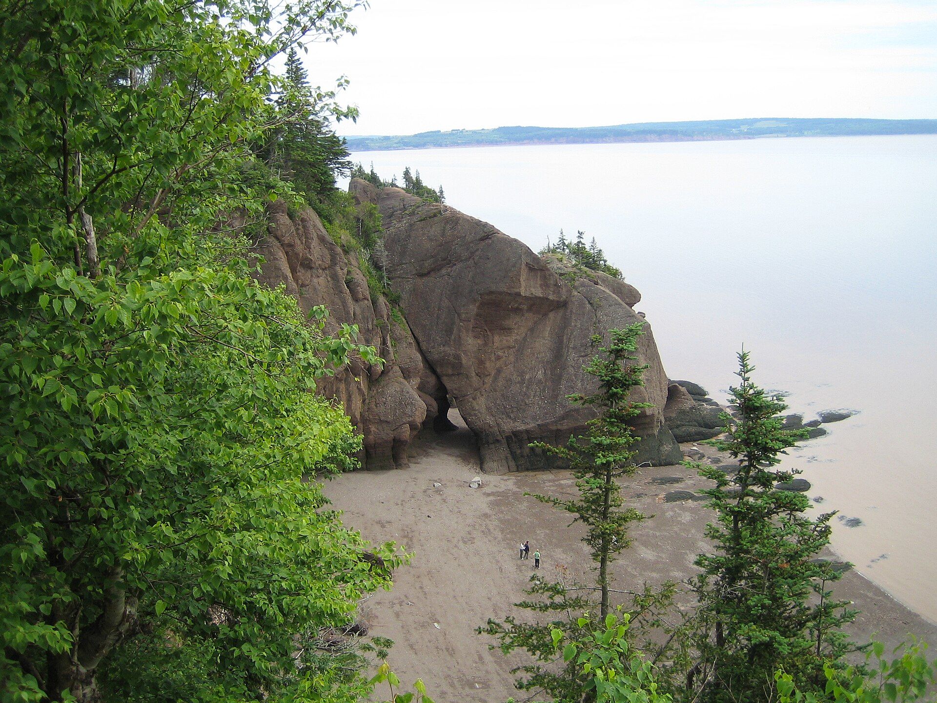
Twice a day, some 100 billion tonnes of seawater surge into and out of the Bay of Fundy, producing the greatest tidal range measured anywhere on the planet — up to about 16 metres, the height of a four-storey building. The cause is resonance: the bay's length and depth happen to match the natural rhythm of the Atlantic tide almost exactly, so each incoming pulse reinforces the last, like a child timing pushes on a swing. The effects are spectacular. At Hopewell Rocks you can walk on the ocean floor at low tide among towering 'flowerpot' sea stacks carved by the water, then watch the same spot vanish beneath the sea hours later. The tides drive rivers backwards in tidal bores, expose vast mudflats that feed millions of migrating shorebirds, and stir up nutrients that draw whales, including the endangered North Atlantic right whale.
Why visit
Standing on a seabed at low tide beneath rock towers, then returning hours later to see that ground buried under metres of ocean, is one of the most vivid demonstrations of natural forces you can witness anywhere.
What to know before you go
🗓️ Best time
Summer to early autumn (roughly June–September) for warm weather, whale watching, and shorebird migration; tide times matter more than season — plan around the tables.
🧭 Getting there & access
Between New Brunswick and Nova Scotia in Atlantic Canada, reached by road; Hopewell Rocks, Fundy National Park, and Burntcoat Head are the main tide-viewing sites, with whale tours from coastal towns.
Good to know
- Plan your visit around the tide tables — see the same spot at low and high tide.
- Heed posted times at Hopewell Rocks; the tide comes in fast and cuts off the beach.
- Add a whale-watching trip in late summer, when feeding is at its peak.
Plan your visit
Easy🧭 Getting there
From Moncton (YQM) or Saint John (YSJ), New Brunswick — Halifax (YHZ) for the Nova Scotia shore
- Fly → Moncton, Saint John or Halifax
- Drive Moncton → Hopewell Rocks — roughly 40–50 minutes
- Drive Moncton → Fundy National Park (Alma) — about 1h30
- Halifax → Burntcoat Head on the Nova Scotia side — about 1h30–2h
- Total travel
- Under two hours from any of the three gateways to a tidal site
- Time at site
- Two or three days to see both low and high water at more than one spot
- Access
- Open access, with entry fees at Hopewell Rocks (provincial) and Fundy National Park (Parks Canada). The one thing that actually governs your visit is the tide table, not opening hours. Ocean-floor walking at Hopewell and Burntcoat is permitted only within a window either side of low water, and staff close the stairs when it ends. Check the day's tide times with Parks Canada or the site operator before you drive.
🎒 What to bring & consider
- The tide table for your specific date, and the discipline to obey it — the range here runs to roughly sixteen metres and the water returns across mudflats faster than people expect. This is the whole trip
- Boots you do not mind ruining, because the sea floor is deep red mud, not sand
- A windproof layer — Fundy fog and wind make it far colder on the shore than the forecast suggests, even in July
- A plan to see the same spot at both low and high water, roughly six hours apart, since one without the other misses the point
- A car: the viewpoints are strung along a long shoreline with no useful public transport
👁️ What to expect
- Crowds
- Hopewell Rocks is busy in summer, and everyone arrives in the same low-tide window because there is no other option. Burntcoat Head and the Fundy Trail are quieter.
- Conditions
- Easy, level walking on mud and gravel. Fog rolls in without warning and the shoreline stays cool.
- Facilities
- Good — visitor centres, cafés, parking and shuttles at the main sites; full services in Alma and Moncton.
- The view
- The same rock arch photographed at low tide with people standing under it and again at high tide with only the trees on top showing. That pair is the picture, and it costs you a six-hour wait rather than any skill.
Times and requirements are approximate and change with season, weather, and local rules — confirm permits, fares, and schedules with operators before you travel.
Natural riches of the area
- The highest tidal range on Earth (up to ~16 m)
- Tidal resonance driving ~100 billion tonnes of water twice daily
- Sea-carved 'flowerpot' rock stacks and tidal bores
- Mudflats feeding millions of migratory shorebirds; feeding whales
Local food
- Atlantic lobster
- The signature catch of Canada's Maritime provinces.
- Scallops & dulse
- Bay of Fundy scallops and dulse, an edible seaweed dried on the shore.
- Wild blueberries
- A famous crop of the Maritimes, in pies and preserves.
Twice a day, roughly 100 billion tonnes of seawater pour into and back out of the Bay of Fundy, producing the greatest tidal range measured anywhere on Earth — as much as sixteen metres, the height of a four-storey building. The reason is resonance: the bay’s length and depth happen to match the natural rhythm of the Atlantic tide almost perfectly, so each incoming surge reinforces the last, like a child timing pushes on a swing.
The results are astonishing to witness. At Hopewell Rocks you can walk across the bare ocean floor at low tide, weaving between towering ‘flowerpot’ sea stacks the water has carved, then come back hours later to find that same ground buried beneath the sea. The tides push rivers backwards in tidal bores, expose vast mudflats that feed millions of migrating shorebirds, and churn up nutrients that draw whales — including the endangered North Atlantic right whale — making Fundy as rich in life as it is in raw force.
Bay of Fundy: common questions
How do you get to Bay of Fundy?
From Moncton (YQM) or Saint John (YSJ), New Brunswick — Halifax (YHZ) for the Nova Scotia shore: Fly → Moncton, Saint John or Halifax; Drive Moncton → Hopewell Rocks — roughly 40–50 minutes; Drive Moncton → Fundy National Park (Alma) — about 1h30; Halifax → Burntcoat Head on the Nova Scotia side — about 1h30–2h. Allow Under two hours from any of the three gateways to a tidal site.
When is the best time to visit Bay of Fundy?
Summer to early autumn (roughly June–September) for warm weather, whale watching, and shorebird migration; tide times matter more than season — plan around the tables.
How long should you spend at Bay of Fundy?
Two or three days to see both low and high water at more than one spot. Under two hours from any of the three gateways to a tidal site of travel from Moncton (YQM) or Saint John (YSJ), New Brunswick — Halifax (YHZ) for the Nova Scotia shore.
What should you bring to Bay of Fundy?
The tide table for your specific date, and the discipline to obey it — the range here runs to roughly sixteen metres and the water returns across mudflats faster than people expect. This is the whole trip Boots you do not mind ruining, because the sea floor is deep red mud, not sand A windproof layer — Fundy fog and wind make it far colder on the shore than the forecast suggests, even in July A plan to see the same spot at both low and high water, roughly six hours apart, since one without the other misses the point A car: the viewpoints are strung along a long shoreline with no useful public transport
Do you need a permit or guide for Bay of Fundy?
Open access, with entry fees at Hopewell Rocks (provincial) and Fundy National Park (Parks Canada). The one thing that actually governs your visit is the tide table, not opening hours. Ocean-floor walking at Hopewell and Burntcoat is permitted only within a window either side of low water, and staff close the stairs when it ends. Check the day's tide times with Parks Canada or the site operator before you drive.
Is Bay of Fundy crowded, and what are conditions like?
Hopewell Rocks is busy in summer, and everyone arrives in the same low-tide window because there is no other option. Burntcoat Head and the Fundy Trail are quieter. Easy, level walking on mud and gravel. Fog rolls in without warning and the shoreline stays cool. Facilities: good — visitor centres, cafés, parking and shuttles at the main sites; full services in Alma and Moncton.
Added
More wonders to explore