Mount Roraima
📍 Canaima National Park, Venezuela
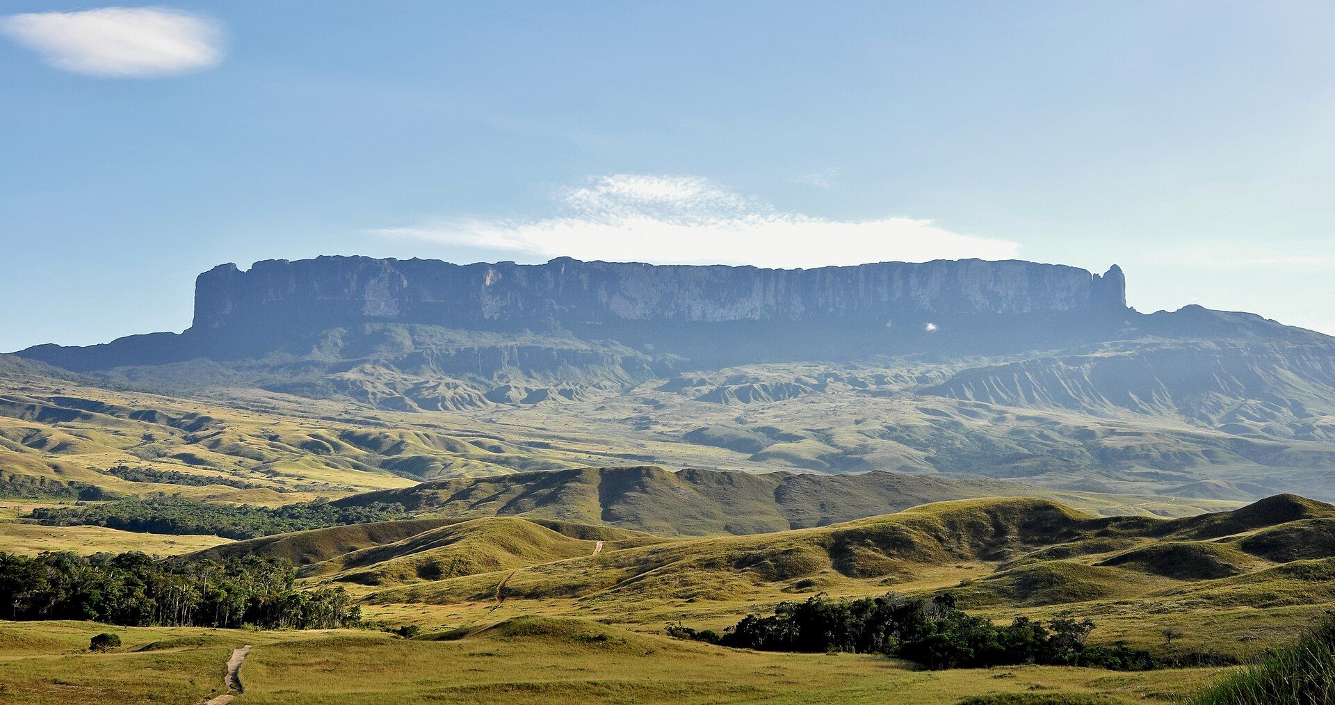
A vast, cloud-wrapped table mountain rising in sheer 400-metre cliffs above the jungle — a 'lost world' plateau of black rock, endemic plants, and waterfalls spilling into the void.
What makes it marvelous
Mount Roraima is the greatest of the tepuis — the ancient flat-topped table mountains where Venezuela, Brazil, and Guyana meet. Its summit plateau stands nearly a kilometre above the surrounding savanna, ringed by sheer cliffs up to 400 metres high that make it look like a fortress adrift in the clouds. On top lies an otherworldly landscape of black sandstone sculpted by rain into bizarre shapes, crystal pools, and quartz fields, home to carnivorous plants and other species found nowhere else on Earth — an evolutionary island in the sky that helped inspire Conan Doyle's 'The Lost World'. The tepuis are among the oldest geological formations on the planet, remnants of a sandstone plateau laid down before life had left the sea.
Why visit
Trekking to the summit of Roraima is one of South America's great adventures — climbing through cloud onto a plateau that feels like another planet, walking among endemic plants and wind-carved rock with the jungle spread out far below.
What to know before you go
🗓️ Best time
The drier months (roughly December–April) make the multi-day trek safer and the summit less cloud-bound, though the tepui generates its own weather year-round.
🧭 Getting there & access
In Canaima National Park, reached via the Gran Sabana and the village of Paraitepui; the summit is gained on a guided multi-day trek up the natural 'ramp' route — the only non-technical way up.
Good to know
- Trek in the drier season with a licensed guide; the route is remote and wet.
- Pack for cold, cloud, and rain on the summit even near the equator.
- Carry out all waste — the fragile plateau ecosystem is easily damaged.
Plan your visit
Expedition🧭 Getting there
From Santa Elena de Uairén, Venezuela
- Reach Santa Elena de Uairén in Venezuela's Gran Sabana, near the Brazil border
- Transfer to Paraitepui, the trailhead village — a few hours by 4x4
- Trek Paraitepui → the summit and back with a guide — roughly 6 days
- Total travel
- A long overland approach to the trailhead
- Time at site
- A six-day guided trek, camping throughout
- Access
- The classic ascent is from the Venezuelan side and is a guided expedition only — a licensed guide and porters are mandatory, both for the route up the one walkable ramp and because this is a protected, fragile plateau. There are no facilities: you camp under rock overhangs on top and carry out every scrap of waste, including human waste, as the guides enforce. The trek is genuinely wet, and the tepui makes its own weather. Venezuela's wider situation means checking your government's current travel advice before committing to this approach.
🎒 What to bring & consider
- A licensed guide and a full organised expedition, which are compulsory and the only way up the mountain
- Total self-sufficiency in camping gear and the readiness to pack out all waste, since the summit is a protected surface with no infrastructure whatsoever
- Serious waterproofs, because the plateau is one of the wettest places imaginable and you will be walking and camping wet
- Boots that cope with deep mud, river crossings and slick rock on the ascent ramp
- A sober check of current travel advice for Venezuela before choosing this side over the longer approaches through Brazil or Guyana
👁️ What to expect
- Crowds
- Very few. This is a committing trek and you may see only your own group for days.
- Conditions
- Wet, muddy and cold on top, through a prehistoric landscape of black rock, pools and endemic plants.
- Facilities
- None. Everything is carried; you sleep under overhangs called "hotels" on the summit.
- The view
- The sheer black walls of the tepui rising out of the savanna on the approach, and the alien rock gardens and quartz pools on the summit plateau. Cloud is near-constant up top, so a clear window is luck as much as timing.
Times and requirements are approximate and change with season, weather, and local rules — confirm permits, fares, and schedules with operators before you travel.
Natural riches of the area
- The largest of the ancient tepui table mountains
- Sheer cliffs up to 400 m ringing a sky-island plateau
- Endemic carnivorous plants and unique summit species
- Wind- and rain-sculpted black sandstone and crystal pools
Local food
- Casabe
- Cassava flatbread made by the Pemón people of the Gran Sabana.
- River fish
- Freshwater fish from the savanna's rivers, a trek-camp staple.
- Trail provisions
- Multi-day treks are supplied by guides and Pemón porters.
Mount Roraima is a genuine lost world. The grandest of the tepuis — the ancient table mountains where Venezuela, Brazil, and Guyana meet — it lifts a summit plateau nearly a kilometre above the savanna, ringed by sheer cliffs up to 400 metres tall that make it look like a fortress drifting in the clouds. Rain and wind have carved its black sandstone summit into an alien landscape of bizarre shapes, quartz fields, and crystal pools.
Because the plateau has stood isolated for so long, life has evolved there in its own direction: carnivorous plants and other species cling to the rock that exist nowhere else on Earth, an island in the sky that helped inspire Conan Doyle’s ‘The Lost World’. The tepuis are among the oldest formations on the planet, sandstone laid down before life crawled from the sea. Trekking to Roraima’s summit — climbing through cloud onto that otherworldly plateau — is one of the great adventures of South America.
Mount Roraima: common questions
How do you get to Mount Roraima?
From Santa Elena de Uairén, Venezuela: Reach Santa Elena de Uairén in Venezuela's Gran Sabana, near the Brazil border; Transfer to Paraitepui, the trailhead village — a few hours by 4x4; Trek Paraitepui → the summit and back with a guide — roughly 6 days. Allow a long overland approach to the trailhead.
When is the best time to visit Mount Roraima?
The drier months (roughly December–April) make the multi-day trek safer and the summit less cloud-bound, though the tepui generates its own weather year-round.
How long should you spend at Mount Roraima?
A six-day guided trek, camping throughout. A long overland approach to the trailhead of travel from Santa Elena de Uairén, Venezuela.
What should you bring to Mount Roraima?
A licensed guide and a full organised expedition, which are compulsory and the only way up the mountain Total self-sufficiency in camping gear and the readiness to pack out all waste, since the summit is a protected surface with no infrastructure whatsoever Serious waterproofs, because the plateau is one of the wettest places imaginable and you will be walking and camping wet Boots that cope with deep mud, river crossings and slick rock on the ascent ramp A sober check of current travel advice for Venezuela before choosing this side over the longer approaches through Brazil or Guyana
Do you need a permit or guide for Mount Roraima?
The classic ascent is from the Venezuelan side and is a guided expedition only — a licensed guide and porters are mandatory, both for the route up the one walkable ramp and because this is a protected, fragile plateau. There are no facilities: you camp under rock overhangs on top and carry out every scrap of waste, including human waste, as the guides enforce. The trek is genuinely wet, and the tepui makes its own weather. Venezuela's wider situation means checking your government's current travel advice before committing to this approach.
Is Mount Roraima crowded, and what are conditions like?
Very few. This is a committing trek and you may see only your own group for days. Wet, muddy and cold on top, through a prehistoric landscape of black rock, pools and endemic plants. Facilities: none. Everything is carried; you sleep under overhangs called "hotels" on the summit.
Added Updated
More wonders to explore