Picos de Europa
📍 Asturias, Cantabria & León, northern Spain
A compact range of sheer limestone peaks rising to 2,600 metres barely 20 kilometres from the Atlantic — glacier-carved gorges, karst towers, and Spain's first national park.
What makes it marvelous
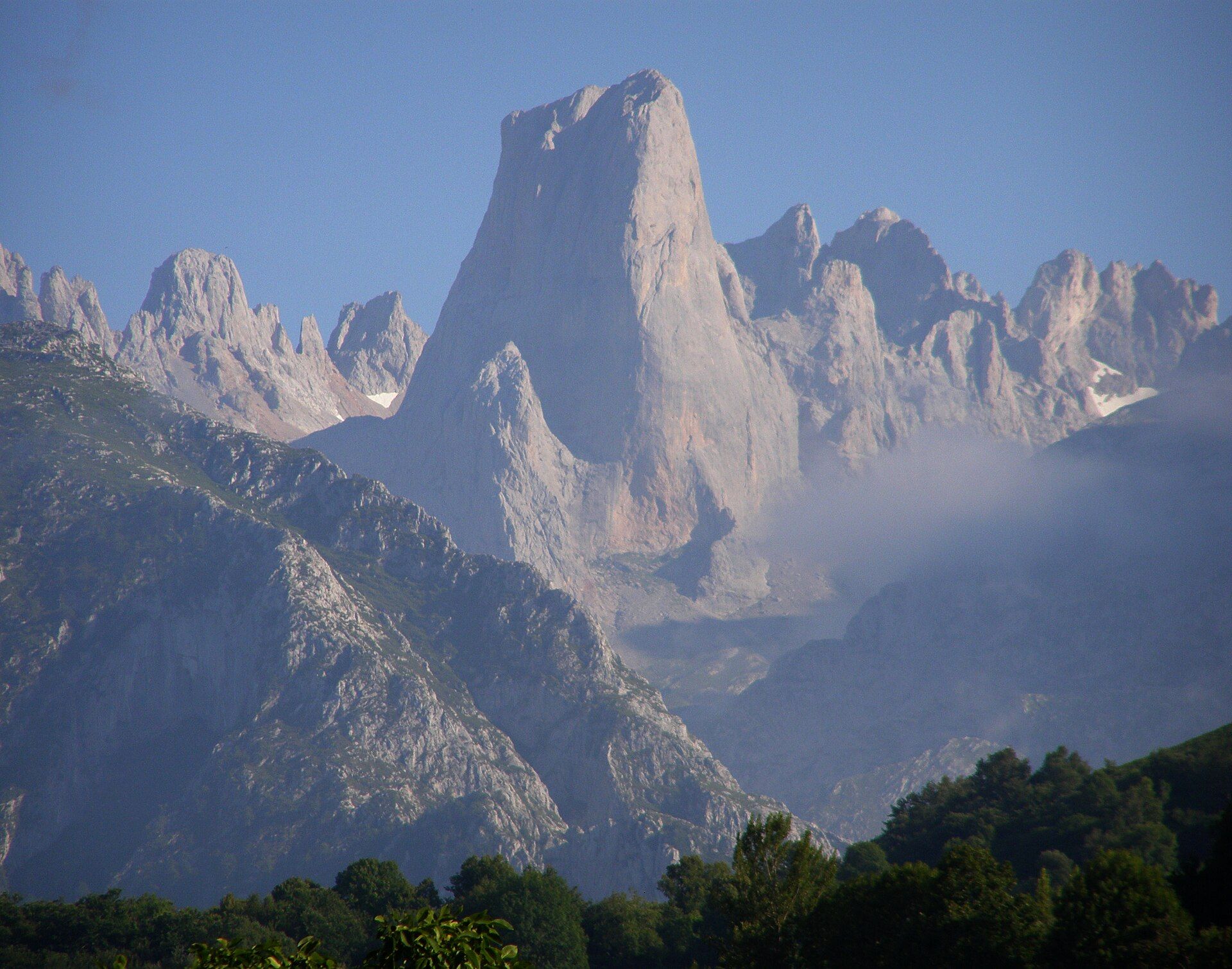
The Picos de Europa are a dramatic block of limestone thrust up in the Cantabrian Mountains and then sculpted by ice and water into knife-edge ridges, deep gorges, and isolated rock towers. The most famous, the Naranjo de Bulnes (Picu Urriellu), is a near-vertical fin of pale limestone about 2,519 metres high, a legendary climb. Because the peaks stand so close to the sea, they catch huge amounts of rain and snow, feeding the karst caves and the gorges that split the range.
Why visit
This is some of the most spectacular mountain scenery in Europe within easy reach of the north coast. The Cares Gorge trail threads a path cut into vertical cliffs above a green river; a cable car at Fuente Dé lifts you to a high plateau of grazing meadows and grey karst; and the glacial lakes of Covadonga sit ringed by peaks. Chamois, griffon vultures, and, unseen, bears and wolves still live here.
What to know before you go
🗓️ Best time
Late spring to early autumn (roughly June–September) for open trails and the cable car; the high country holds snow into early summer and weather turns fast year-round.
🧭 Getting there & access
Reached from Oviedo, Santander, or León in northern Spain. Gateway villages include Cangas de Onís, Potes, and Arenas de Cabrales; the Fuente Dé cable car and the Cares Gorge trailheads are the main access points.
Good to know
- Walk the Cares Gorge early — it is popular and there is little shade on the cliff path.
- Carry rain gear whatever the forecast; the range makes its own weather off the Atlantic.
- The Lakes of Covadonga road is often shuttle-only in peak season — check before driving up.
Plan your visit
Moderate🧭 Getting there
From Oviedo (OVD) or Santander (SDR), northern Spain
- Fly to Asturias or Santander, or drive from Bilbao or Madrid
- Road to a gateway village such as Potes, Cangas de Onís, or Arenas de Cabrales — 1–2h
- Trailheads and the Fuente Dé cable car are a short drive on from there
- Total travel
- Most of a travel day from Madrid; a couple of hours from the north coast
- Time at site
- A day for the cable car or the Cares Gorge; several days to explore properly
- Access
- The park is free to enter. The Fuente Dé cable car is ticketed and weather-dependent. The Covadonga lakes road runs a seasonal shuttle-and-permit system in summer to limit traffic — check the current rules.
🎒 What to bring & consider
- Proper walking shoes — trails are rocky and the Cares path has long unfenced drops
- Rain and wind layers; Atlantic weather sweeps in quickly
- Water and food for the trail; villages are the last reliable supply
- A head for heights on the gorge and cable-car routes
👁️ What to expect
- Crowds
- The Cares Gorge, Fuente Dé, and the Covadonga lakes are busy in July–August; shoulder seasons and early starts are far quieter.
- Conditions
- Well-made but exposed mountain trails, steep in places, with fast-changing weather and frequent low cloud.
- Facilities
- Good in the gateway towns — hotels, food, guides. Mountain refuges serve the high routes; little in between.
- The view
- The Naranjo de Bulnes tower catching first or last light, or the green thread of the Cares River far below the cliff path. Low cloud can hide the peaks for days, so build in time.
Times and requirements are approximate and change with season, weather, and local rules — confirm permits, fares, and schedules with operators before you travel.
Natural riches of the area
- Glacier-carved limestone peaks and knife-edge ridges
- Deep river gorges, including the Cares, and extensive karst caves
- Glacial lakes and rain-fed rivers
- Chamois, griffon vultures, and the Cantabrian brown bear
Local food
- Cabrales cheese
- A pungent blue cheese cave-aged in the Picos, a protected regional specialty.
- Fabada asturiana
- A hearty Asturian stew of white beans, chorizo, and cured pork.
The Picos de Europa pack an astonishing amount of mountain into a small area: three limestone massifs, riven by gorges and studded with rock towers, rising to over 2,600 metres less than 20 kilometres from the Atlantic. That closeness to the sea is the key to the whole landscape — moisture-laden air dumps rain and snow on the peaks, which over millions of years dissolved and carved the limestone into caves, sinkholes, and the sheer-walled gorges that make the range famous. Legend says returning sailors took the peaks as their first sight of Europe, giving them their name.
The signature walk is the Ruta del Cares, a path blasted into vertical cliffs high above a river, but the range offers much more: the cable car at Fuente Dé to a karst plateau, the glacial Lakes of Covadonga, and quiet valleys where chamois graze and griffon vultures wheel overhead. Protected as Spain’s very first national park in 1918, it remains a stronghold for the rare Cantabrian brown bear.
Picos de Europa: common questions
How do you get to Picos de Europa?
From Oviedo (OVD) or Santander (SDR), northern Spain: Fly to Asturias or Santander, or drive from Bilbao or Madrid; Road to a gateway village such as Potes, Cangas de Onís, or Arenas de Cabrales — 1–2h; Trailheads and the Fuente Dé cable car are a short drive on from there. Allow Most of a travel day from Madrid; a couple of hours from the north coast.
When is the best time to visit Picos de Europa?
Late spring to early autumn (roughly June–September) for open trails and the cable car; the high country holds snow into early summer and weather turns fast year-round.
How long should you spend at Picos de Europa?
A day for the cable car or the Cares Gorge; several days to explore properly. Most of a travel day from Madrid; a couple of hours from the north coast of travel from Oviedo (OVD) or Santander (SDR), northern Spain.
What should you bring to Picos de Europa?
Proper walking shoes — trails are rocky and the Cares path has long unfenced drops Rain and wind layers; Atlantic weather sweeps in quickly Water and food for the trail; villages are the last reliable supply A head for heights on the gorge and cable-car routes
Do you need a permit or guide for Picos de Europa?
The park is free to enter. The Fuente Dé cable car is ticketed and weather-dependent. The Covadonga lakes road runs a seasonal shuttle-and-permit system in summer to limit traffic — check the current rules.
Is Picos de Europa crowded, and what are conditions like?
The Cares Gorge, Fuente Dé, and the Covadonga lakes are busy in July–August; shoulder seasons and early starts are far quieter. Well-made but exposed mountain trails, steep in places, with fast-changing weather and frequent low cloud. Facilities: good in the gateway towns — hotels, food, guides. Mountain refuges serve the high routes; little in between.
Added
More wonders to explore